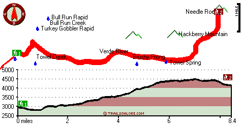
| |
|
| | With so many outdoors pursuits available in Arizona you'll never get bored. Alright, enough of spending all this time inside a building, time to get out, and Towel Creek Trail in Yavapai County, Arizona is a magnificent pick. Each one of the many wilderness hiking trails of Arizona has something unique to offer. The total elevation difference for this wilderness hiking trail is 1,807 feet, and that is about average. Don’t forget to check for any current restrictions or closures before you go. Trekking here in Arizona is a splendid way to spend some time. |
|
Now, this is roughly a 2.5-day backcountry walk, so better have big backpack to fit all the stuff you need. Towel Creek Trail gets very little precipitation; throughout the month of August you get the most rain around here, and May is the month with the least moisture. This great
| | outdoors hiking trail sometimes gets very dry, so make sure you check current conditions and fire restrictions with local forest authorities before you head out. For the period of the long summer days here at Towel Creek Trail, high temperatures mostly get into the 100's with night lows in the 60's. High temperatures through the winter are normally in the 50's with temperatures at Towel Creek Trail dipping down into the 20's through winter nights. The length of Towel Creek Trail is on the longer side with an average amount of climbing distance which makes | |
|
this a very tough wilderness trail for advanced trekkers looking for a perfect challenge. Towel Creek Trail is 16.8 miles long; it's considered a longer backcountry trek. This is a neighborhood covered with lots of wilderness trails. Some parts of Towel Creek Trail are much higher
up than other parts of the hiking trail which of course means you need to be prepared for different conditions on different parts of the hiking trail. Now this great outdoors hiking trail is pretty long, so don't forget to pack enough supplies. Arizona has plenty of wonderful wilderness
hiking trails, and Towel Creek Trail in Yavapai County is one of them. Towel Creek Trail is positioned a pretty long drive from Prescott, but you always have a magnificent time when you're backcountry trekking along it. Towel Creek Trail has two trailheads, so if you can get a
ride from someone, you can hike it just one way.
Briefly about the general area: Cimarron Creek is right next door to Towel Creek Trail and is always a diversion to have a look at; Towel Creek Trail is wonderful enough to spend more than a day at, Zane Grey Recreational
Vehicle Park is a wonderful local campground. Hackberry Springs is a pretty location to check out while you're at Towel Creek Trail. There's so much to do here at Towel Creek Trail that you need to camp here for a while, Clear Creek Campground is a good place for that. Towel
Spring is always fun to check out, and Montezuma Castle National Monument is a tremendous national park. There are some splendid whitewater spots on Verde River, and close by High Saddle is a tremendous place to go. What a place this is for outdoors people. Take some time to have
a look at The Cedars if you're here, and get yourself into a kayak and hit Verde River. Hackberry Basin is a good location. There's some flowing water close by, Brushy Prong is a stream you can stop by while you're here, and everyone loves Fossil Pocket.
|
|
Location of Trailhead 1: Latitude 34.4146, Longitude -111.789 - - Directions and Road Map
Location of Trailhead 2: Latitude 34.435, Longitude -111.6888 - - Directions and Road Map

Trailhead 1 to Trailhead 2: Total hiking length = 8.4 miles Total climbing distance = 4.9 miles Difficulty : Difficult Casual Hiking Pace:
8.5 hours
Fast Hiking Pace:
4.5 hours
Trailhead 2 to Trailhead 1: Total hiking length = 8.4 miles Total climbing distance = 2.2 miles Difficulty : Difficult Casual Hiking Pace:
6.5 hours
Fast Hiking Pace:
3.5 hours
| | Trailhead 1 back to Trailhead 1: Total hiking length = 16.8 miles Total climbing distance = 7.1 miles Difficulty : Difficult Casual Hiking Pace:
2.5 days
Fast Hiking Pace:
1.5 days
Trailhead 2 back to Trailhead 2: Total hiking length = 16.8 miles Total climbing distance = 7.1 miles Difficulty : Difficult Casual Hiking Pace:
2.5 days
Fast Hiking Pace:
1.5 days
|
Total elevation difference: 1807 feet

Camp Verde Super 8 Motel, Camp Verde
|
15 miles away
* Pride of Super 8 * Halfway between Phoenix and the Grand Canyon on I-17, exit 287 * Forte Verde Historical Park is 1.5 Miles * Free Wireless High Speed Internet Access * Within a coup...
|
| |
Days Inn Camp Verde, Camp Verde
|
16 miles away
The Days Inn Camp Verde, Arizona is a Chairman Award Hotel centrally located off Interstate 17, halfway between Phoenix & Flagstaff.* Camp Verde is know for Western Culture, Native American Ruins, Wi...
|
|
User input for Towel Creek Trail, Yavapai County, Arizona:

Outdoors Recreation Near Prescott, Arizona Very comprehensive list of a variety of outdoors recreation in the vicinity of Prescott, Arizona, the metro area neareast to Towel Creek Trail. Find info on campgrounds, hiking trails, ski resorts, lakes, beaches, parks, whitewater and more.
More Hotels and Campgrounds Near Towel Creek Trail, Yavapai County, Arizona
| |
| |
 |
|
| These outdoors activities are available near Towel Creek Trail. |
| | Trails Near Towel Creek Trail:
 |
Towel Creek Trail Sixty Six - Sixty Seven Loop, Yavapai
County
, 3 miles away, 5.8 hiking miles, 2408 feet elevation difference |
 |
Cold Water Trail, Yavapai
County
, 7 miles away, 13 hiking miles, 3883 feet elevation difference |
 |
Ox Bow Trail Number One Hundred Sixty Three, Yavapai
County
, 9 miles away, 7.2 hiking miles, 3097 feet elevation difference |
 |
Buckhorn Trail, Yavapai
County
, 10 miles away, 3.7 hiking miles, 1912 feet elevation difference |
 |
Nelson Trail Number One Hundred Fifty Nine, Yavapai
County
, 11 miles away, 8.7 hiking miles, 1407 feet elevation difference |
 |
Pine Flat Trail, Yavapai
County
, 11 miles away, 4.1 hiking miles, 1227 feet elevation difference |
|
| | Whitewater Near Towel Creek Trail:
 |
Verde River, Yavapai County
County
, 4 miles away, Class II-IV - 7 miles long (Beasley Flat to Gap Creek) |
 |
Verde River, Yavapai County
County
, 11 miles away, Class -blank- - 8 miles long (Camp Verde to Beasley Flat) |
 |
Verde River, Yavapai County
County
, 14 miles away, Class I-III - 25 miles long (Childs to Horseshoe Reservoir) |
 |
Wet Beaver Creek, Yavapai County
County
, 14 miles away, Class -blank- - 9 miles long (Beaver Ranger Station to Beaver Creek) |
 |
Beaver Creek, Yavapai County
County
, 14 miles away, Class -blank- - 9 miles long (Wet Beaver Creek to Verde River) |
|
| | National Parks Near Towel Creek Trail:
 |
Montezuma Castle National Monument, Camp Verde - AZ
, 13 miles away |
 |
Tuzigoot National Monument, Clarkdale - AZ
, 13 miles away |
 |
Walnut Canyon National Monument, Flagstaff - AZ
, 47 miles away |
|
| | Hotels Near Towel Creek Trail:
 |
Camp Verde Super 8 Motel, Camp Verde
, 15 miles away |
 |
Days Inn Camp Verde, Camp Verde
, 16 miles away |
 |
Comfort Inn Camp Verde, Camp Verde
, 16 miles away |
 |
Lodge at Cliff Castle, Camp Verde
, 16 miles away |
 |
Las Posadas of Sedona, Sedona
, 21 miles away |
|
|
|
 |
|