| |
|
| | Finally, backcountry backpacking time is here again, and if you happen to be in Yavapai County of Arizona, Table Mountain Trail is an outstanding local hiking trail for doing a bit of leg stretching. Quite far from Phoenix-Mesa-Scottsdale you encounter Table Mountain Trail, but it is an enjoyable location to trek. Arizona is a wonderful site for outdoors people. Table Mountain Trail has a total elevation difference of 3,116 feet, and that is higher than average. This hiking trail has only one trailhead, so you're looking at an in and out hike. Please |
|
follow all local rules about fires and camping. This is a region covered with lots of backpacking trails. At parts of the year this area sees very little rain, so do check for current fire restrictions before you go if you plan to bring a stove or make a camp fire. The beautiful
| | wilderness hiking trails of the Mogollon Rim Mountains are a really good way to spend quality time in the fresh air. Table Mountain Trail is quite long, so don't forget to pack enough supplies. Around Table Mountain Trail you don’t get a lot of rain; of all the months in a year August is the one with the most rain; June is when it's the driest. The length of Table Mountain Trail is on the longer side with an average amount of climbing distance which makes it a good backpacking trail for experienced backcountry walkers in perfect shape. Different parts | |
|
of Table Mountain Trail are at very different elevations, and that means that some parts of the wilderness trail could be very different from other parts of it. Now, this is roughly a 4-day trek, so make sure you've got all your overnight gear packed. Backcountry trails for hiking,
and backpacking can be found all over Arizona; one of these is Table Mountain Trail in Yavapai County. If you happen to be in Arizona, why not go hiking, it is a tremendous way to spend some time. There are numerous wilderness trails in Arizona, and each one is different from the
others. Through the warm days of summer here at Table Mountain Trail, high temperatures mostly get into the 100's. Summer nighttime lows plunge down to the 60's. The wintertime comes with highs in the 50's while Table Mountain Trail nighttime low temperatures through the wintertime
are in the 30's. Being 27.2 miles long; it's considered a longer hike.
Briefly about the general area: Bear Creek flows through this area, and Mesquite Spring is a lovely place to pop by while you're at Table Mountain Trail. A delightful location next to Table Mountain
Trail is Red Metal Canyon, and there's whitewater on Verde River for all you adrenaline rush seekers. Having a brilliant time at Table Mountain Trail is easy. If you came to camp Oxbow Estates RV Park is a great spot to do that; some fine nature is available in Cypress Thicket.
Mountain Spring is always fun to check out, and a brilliant location like Willow Spring Basin here at Table Mountain Trail is too fine to miss. So much amusing stuff in the Mogollon Rim Mountains, just incredible. If you're here at Table Mountain Trail, you could pop by Mazatzal
Wash, and you must certainly dedicate some time to Granite Basin if you're here at Table Mountain Trail. And that's not everything there is to do here in the Mogollon Rim Mountains. Devils Hole is not far from Table Mountain Trail at all, and Table Mountain Trail is good enough to spend more than a day at, Kool Oaks Trailer Park is a good local campground.
|
|
Location of Trailhead: Latitude 34.0074, Longitude -111.6398 - - Directions and Road Map
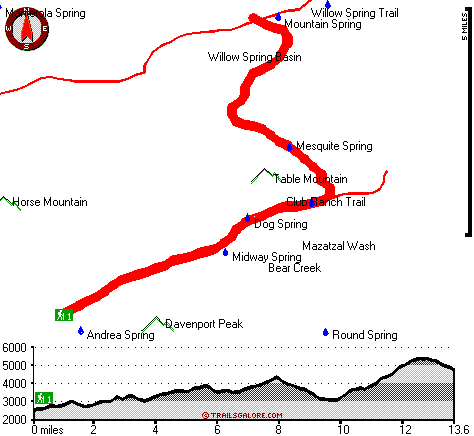
Total in and out hiking length = 27.2 miles
Total climbing distance = 12.7 miles
Difficulty : Difficult
Casual Hiking Pace:
4 days
Fast Hiking Pace:
2.5 days
Total elevation difference: 3116 feet

Paysonglo Lodge, Payson
|
19 miles away
Nestled among the majestic mountains of the Mogollon Rim lies a unique and serene Payson Arizona hotel: Paysonglo Lodge. The perfect spot for a Payson AZ hotel getaway. Here in Payson we offer more...
|
| |
Americas Best Value Inn - Payson, Payson
|
20 miles away
Welcome to the Americas Best Value Inn. Our hotel is strategically located in Payson, the largest community in Arizona Rim Country. Payson is also one of the fastest growing vacation centers in the ar...
|
|
User input for Table Mountain Trail, Mogollon Rim Mountains, Yavapai County, Arizona:

Outdoors Recreation Near Phoenix-Mesa-Scottsdale, Arizona Very comprehensive list of a variety of outdoors recreation in the vicinity of Phoenix-Mesa-Scottsdale, Arizona, the metro area neareast to Table Mountain Trail. Find info on campgrounds, hiking trails, ski resorts, lakes, beaches, parks, whitewater and more.
|
Current weather conditions at Table Mountain Trail, Mogollon Rim Mountains, Yavapai County, Arizona

Local climate location: CHILDS 13 miles away

           
| |
Days Inn and Suites Payson, Payson
|
20 miles away
Welcome to the Days Inn & Suites of Payson. When you are visiting Payson next, take refuge in this comfortable interior hotel. Experience the difference and we are sure you will make it your home aw...
|
Holiday Inn Express PAYSON, Payson
|
20 miles away
Payson is nestled among the Ponderosa pines and clean air of the Mogollon Rim. The Tonto Natural Bridge, camping, hiking, fishing, hunting and boating areas are a short drive away. The Holiday Inn Exp...
|
|
More Hotels and Campgrounds Near Table Mountain Trail, Mogollon Rim Mountains, Yavapai County, Arizona
| |
| |
 |
|
| These outdoors activities are available near Table Mountain Trail. |
| | Trails Near Table Mountain Trail:
 |
Willow Spring Trail, Yavapai
County
, 2 miles away, 34.2 hiking miles, 5105 feet elevation difference |
 |
Club Ranch Trail, Yavapai
County
, 4 miles away, 25 hiking miles, 3154 feet elevation difference |
 |
Mazatzal Divide, Yavapai
County
, 6 miles away, 26.3 hiking miles, 4287 feet elevation difference |
 |
Barnhardt Trail, Gila
County
, 7 miles away, 11.6 hiking miles, 2143 feet elevation difference |
 |
Verde River Trail Number Eleven, Yavapai
County
, 9 miles away, 14.6 hiking miles, 462 feet elevation difference |
 |
North Peak Trail, Gila
County
, 9 miles away, 8.2 hiking miles, 2380 feet elevation difference |
 |
Shake Tree Trail, Gila
County
, 10 miles away, 10.2 hiking miles, 2355 feet elevation difference |
|
| | Whitewater Near Table Mountain Trail:
 |
Verde River, Yavapai County
County
, 10 miles away, Class I-III - 25 miles long (Childs to Horseshoe Reservoir) |
 |
Verde River, Yavapai / Maricopa County
County
, 10 miles away, Class I-II - 19 miles long (Horseshoe Reservoir to Bartlett Reservoir) |
 |
East Verde River, Gila County
County
, 13 miles away, Class V+ - 34 miles long (US Route 87 to Verde River confluence) |
 |
Tonto Creek, Gila County
County
, 20 miles away, Class IV(V) - 2 miles long (Box) |
 |
Verde River, Yavapai County
County
, 22 miles away, Class II-IV - 7 miles long (Beasley Flat to Gap Creek) |
|
| | National Parks Near Table Mountain Trail:
 |
Montezuma Castle National Monument, Camp Verde - AZ
, 33 miles away |
 |
Tonto National Monument, Roosevelt - AZ
, 48 miles away |
 |
Casa Grande Ruins National Monument, Coolidge - AZ
, 64 miles away |
|
| | Hotels Near Table Mountain Trail:
 |
Paysonglo Lodge, Payson
, 19 miles away |
 |
Americas Best Value Inn - Payson, Payson
, 20 miles away |
 |
Days Inn and Suites Payson, Payson
, 20 miles away |
 |
Holiday Inn Express PAYSON, Payson
, 20 miles away |
 |
Best Western Payson Inn, Payson
, 20 miles away |
|
|
|
 |
|