Arizona hiking trails - Steeple Mesa Seventy-Three Trail, San Francisco Mountains, Greenlee County

   
  Great outdoors hiking trails are delightful and plentiful in Arizona, and among these are Steeple Mesa Seventy-Three Trail in Greenlee County. You can't spend all your time indoors you need to get out once in a while, and Steeple Mesa Seventy-Three Trail in Greenlee County, Arizona is a good spot for getting out. You'll need to go far from Safford to get to Steeple Mesa Seventy-Three Trail, but It's always enjoyable to backcountry trek here. There are two trailheads to chose from, one in each end, so backpacking it one way is an option if you can arrange
    for a ride back. This backcountry hike should take you about 4.5 days, so make sure you've got all your overnight gear packed. The total elevation difference for Steeple Mesa Seventy-Three Trail is 2,887 feet, and that is higher than average. Please follow all local rules about
fires and camping. Every hiking trail in Arizona is worth backcountry trekking. Steeple Mesa Seventy-Three Trail is 29.2 miles long; it's considered a longer walk. Steeple Mesa Seventy-Three Trail is quite long, so make sure you bring plenty of supplies. Hiking in Arizona is always an amusing thing to do. Steeple Mesa Seventy-Three Trail is a wilderness hiking trail of good length having an average number of uphill miles which makes this hiking and backpacking trail pleasant for hard core backpackers looking for adventure. Throughout the summer months highs  
here at Steeple Mesa Seventy-Three Trail get into the 70's while overnight lows are commonly in the 40's. High temperatures all through the winter are normally in the 40's while the cold winter nights at Steeple Mesa Seventy-Three Trail are in the 10's. It is very dried out here at Steeple Mesa Seventy-Three Trail generally; August is when you get the most rain here; May on the other hand is the driest. This wilderness trail goes through some very different elevations, so keep in mind that you may need to dress differently at different elevations. These wilderness hiking trails here in the San Francisco Mountains are the best way to enjoy these mountains. As long as you like nature you will like Arizona. This is an area covered with lots of hiking and backpacking trails. This trail sometimes gets very dry, so don’t forget to check for any current fire restrictions before you go.

Briefly about the general area:
Camping at Steeple Mesa Seventy-Three Trail is pleasant fun, Hannagan Campground is a pleasant local campground; some of the water nearby flows, like Panther Creek. Alpine Ranger District is worth taking a look at, and a nice place like Moonshine Park here at Steeple Mesa Seventy-Three Trail is too wonderful to miss.
If only every place had this much outdoors cool stuff, what a great earth it would be. Steeple Creek is a splendid local stream, and don’t forget to pop by Raspberry Basin since you're here at Steeple Mesa Seventy-Three Trail. If you want a delightful time in the great outdoors just come on up to the San Francisco Mountains. A trip to Grasshopper Spring will fill your spirit with great feelings, and whitewater paddling is not for everybody but if it's for you then, we recommend Black River - East Fork. This river is so perfect. Don't leave Steeple Mesa Seventy-Three Trail without first paying a visit to Mud Spring, and if you come at the right time of year, Blue River offers some fine whitewater.
These mountains rock, just explore all the amusing stuff to do in the San Francisco Mountains. Since you're here at Steeple Mesa Seventy-Three Trail why not go to Red Saddles, and why not camp at Stray Horse Campground while you're here at Steeple Mesa Seventy-Three Trail. This river is a great place to visit.

Location of Trailhead 1: Latitude 33.5729, Longitude -109.179
- - Directions and Road Map

Location of Trailhead 2: Latitude 33.5438, Longitude -109.2021
- - Directions and Road Map


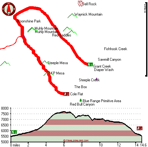
Trailhead 1 to Trailhead 2:
Total hiking length = 14.6 miles
Total climbing distance = 7.3 miles
Difficulty : Difficult
Casual Hiking Pace: 2.5 days
Fast Hiking Pace: 7.5 hours

Trailhead 2 to Trailhead 1:
Total hiking length = 14.6 miles
Total climbing distance = 5.8 miles
Difficulty : Difficult
Casual Hiking Pace: 2 days
Fast Hiking Pace: 7 hours
    Trailhead 1 back to Trailhead 1:
Total hiking length = 29.2 miles
Total climbing distance = 13.1 miles
Difficulty : Difficult
Casual Hiking Pace: 4.5 days
Fast Hiking Pace: 3 days

Trailhead 2 back to Trailhead 2:
Total hiking length = 29.2 miles
Total climbing distance = 13.1 miles
Difficulty : Difficult
Casual Hiking Pace: 4.5 days
Fast Hiking Pace: 3 days

Total elevation difference: 2887 feet


Best Western Sunrise Inn, Eagar
30 miles away
Located in Arizona's scenic White Mountains, this Eagar, Arizona hotel prides itself on superior customer service and is close to Sunrise Ski Resort. Situated on Main Street in Eagar, the Best Weste...
  
User input for Steeple Mesa Seventy-Three Trail, San Francisco Mountains, Greenlee County, Arizona:

Submit Input:
Your Name:
Write or Paste Input here:

Upload picture:      Review Guidelines


Outdoors Recreation Near Safford, Arizona
Very comprehensive list of a variety of outdoors recreation in the vicinity of Safford, Arizona, the metro area neareast to Steeple Mesa Seventy-Three Trail. Find info on campgrounds, hiking trails, ski resorts, lakes, beaches, parks, whitewater and more.

Current weather conditions at Steeple Mesa Seventy-Three Trail, San Francisco Mountains, Greenlee County, Arizona
WXPort

Local climate location: ALPINE 12 miles away


More Hotels and Campgrounds Near Steeple Mesa Seventy-Three Trail, San Francisco Mountains, Greenlee County, Arizona

OTHER_INFO
  San Francisco Mountains Campgrounds
Complete list of all the campgrounds in the San Francisco Mountains.

San Francisco Mountains Outdoors Info
Complete outdoors info for the San Francisco Mountains.

Arizona Hiking Trails
Complete list of all hiking trails in Arizona

Books about hiking trails in Arizona
List of books available on Amazon.com about hiking trails in Arizona.

Arizona Outdoors Index
This is a very comprehensive index of outdoors activities in the great state of Arizona.


TOPO
High quality water resistant topo map of Steeple Mesa Seventy-Three Trail, San Francisco Mountains, Greenlee County, Arizona.

OUTDOORS_GUIDE
These outdoors activities are available near Steeple Mesa Seventy-Three Trail.
 Trails Near Steeple Mesa Seventy-Three Trail:
Raspberry Trail Thirty-five, Greenlee County , 4 miles away, 8.1 hiking miles, 3036 feet elevation difference
KP Trail Seventy, Greenlee County , 5 miles away,  15.2 hiking miles, 2663 feet elevation difference
Foote Creek Seventy-six Trail, Greenlee County , 6 miles away, 9.5 hiking miles, 2865 feet elevation difference
Stray Horse Canyon Trail Twenty, Greenlee County , 6 miles away,  13.6 hiking miles, 894 feet elevation difference
Lengthy Canyon Trail Eighty-nine, Greenlee County , 6 miles away,  4.4 hiking miles, 1277 feet elevation difference
Salt House Eighteen Trail, Greenlee County , 7 miles away,  6.4 hiking miles, 903 feet elevation difference
Crabtree Trail Twenty-two, Greenlee County , 8 miles away,  11.2 hiking miles, 1810 feet elevation difference
 Camp Grounds Near Steeple Mesa Seventy-Three Trail:
Stray Horse Campground, Greenlee County, 6 miles away
Hannagan Campground, Greenlee County, 6 miles away
KP Cienega Campground, Greenlee County, 8 miles away
Blue Crossing Campground, Greenlee County, 10 miles away
Upper Blue Campground, Greenlee County, 13 miles away
 Whitewater Near Steeple Mesa Seventy-Three Trail:
Blue River, Greenlee County County , 8 miles away, Class IV-V - 34 miles long (Blue Crossing to Forest Service Road 475)
Black River - East Fork, Apache County County , 14 miles away, Class -blank- - 18 miles long (Diamond Rock to Wildcat Point)
San Francisco River, Greenlee County County , 25 miles away, Class -blank- - 40 miles long (Alma to Clifton)
San Francisco River, Catron County County , 28 miles away, Class II - 40 miles long (Lower San Francisco Hot Springs to Clifton Arizona)
San Francisco River, Catron County County , 30 miles away, Class II-III - 40 miles long (San Francisco to Pleasanton)
 Hotels Near Steeple Mesa Seventy-Three Trail:
Alpine Cabins, Alpine , 15 miles away
Tal Wi Wi Lodge, Alpine , 15 miles away
Sportsman Lodge, Alpine , 16 miles away
Mountain Hi Lodge, Alpine , 16 miles away
Crab Apple Cabins, Glenwood , 27 miles away
 Lakes Near Steeple Mesa Seventy-Three Trail
P Bar Lake, Greenlee County , 3 miles away
Thomas Lake, Greenlee County , 5 miles away

Outdoors related information copyright © Stratus-Pikpuk, Inc. - Detailed hotel information copyright © Interactive Hotel Solutions