Arizona hiking trails - Soldier Camp Trail, Mogollon Rim Mountains, Maricopa County

   
  Soldier Camp Trail is located a relatively lengthy trip from Payson, but great outdoors trails like these are nice. Backcountry trekking here in Arizona is a nice way to spend some time. Arizona is a glorious site for backcountry hikers. Backcountry trails for backcountry hiking, and backpacking can be found all over Arizona, and one of these is Soldier Camp Trail in Maricopa County. Every single Arizona hiking trail has its own unique splendor. The total elevation difference for Soldier Camp Trail is 2,657 feet which is a higher than average number. Please
    follow all local rules about fires and camping. Summer at Soldier Camp Trail comes with high temperatures in the 100's. For the duration of the dark hours of summer temperatures dip down into the 70's. Daytime highs during the wintertime are in the 60's, and nighttime lows in the
30's for Soldier Camp Trail. The length of this hiking trail is on the longer side having an average number of uphill miles which makes this trail pleasant for hard core backpackers looking for adventure. Alright, enough of spending all this time inside a building, time to get out, and Soldier Camp Trail in Maricopa County, Arizona is just the place. Soldier Camp Trail is a location that is quite dry frequently; of all the months in a year December is the one with the most rain while June is frequently the driest month. This region does get very dry  
sometimes, so don’t forget to check for any current fire restrictions before you go. Now, this is roughly a 2-day walk, so it's an outstanding thing if your backpack is big enough to do the job. Some parts of this backpacking trail are much higher up than other parts of the backpacking trail, so keep in mind that you may need to dress differently at different elevations. Soldier Camp Trail is a one trailhead great outdoors trail, so in and out is the way to backcountry trek it normally. This is a hiking trail that is quite long, so don't forget to pack enough supplies. This is an area covered with lots of trails. The hiking trails of the Mogollon Rim Mountains are a very delightful way to see these hills. Being 14.4 miles long; it's a long backpacking trail.

Briefly about the general area:
Yep, outdoors exciting stuff truly is bountiful here in the Mogollon Rim Mountains. Mud Spring is a great local attraction, and Fish Creek is in close proximity to Soldier Camp Trail and is always a bliss to stop by. Lots of fun awaits you along this river. There's some flowing water nearby, Alder Creek is a stream you can go to during your stay, and a visit to Big Pine Flat rejuvenates the soul.
Mesa Ranger District is a great local forest; if you crave a little side trip, try Big Saddle. There's no way somebody can get bored here in the Mogollon Rim Mountains. Get yourself into a kayak and hit Salt River; Brushy Basin is a great spot. Put some time aside to spend at Four Peaks Spring Number One if you're here at Soldier Camp Trail. You'll need more than a day to explore everything Soldier Camp Trail has to offer, you can camp at Burnt Corral Campground.
Not sufficient hours in a day to enjoy this site. Soldier Camp Trail is a pleasant site to camp, Apache Lake Campground is a pleasant site, and get drenched paddling on Tonto Creek. At this river you will always have a good time.

Location of Trailhead: Latitude 33.7024, Longitude -111.3608
- - Directions and Road Map

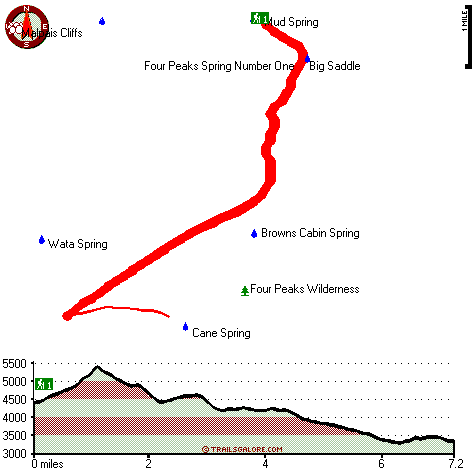
Total in and out hiking length = 14.4 miles

Total climbing distance = 6.4 miles

Difficulty : Difficult

Casual Hiking Pace: 2 days

Fast Hiking Pace: 8.5 hours

Total elevation difference: 2657 feet


Gold Canyon Golf Resort, Gold Canyon
19 miles away
The resorts 85 unique Casitas offer a variety of amenities such as Indoor or Outdoor Spas, Suites, Wood Burning Fireplaces, and Private Patios with splendid views of the majestic Superstition Mountain...
  
Best Western Gold Canyon Inn & Suites, Gold Canyon
20 miles away
Discover this Gold Canyon hotel located next to the Superstition Mountains and offering a complimentary continental breakfast. Whether traveling on business or for pleasure, the Best Western Gold Can...
User input for Soldier Camp Trail, Mogollon Rim Mountains, Maricopa County, Arizona:

Submit Input:
Your Name:
Write or Paste Input here:

Upload picture:      Review Guidelines


Outdoors Recreation Near Payson, Arizona
Very comprehensive list of a variety of outdoors recreation in the vicinity of Payson, Arizona, the metro area neareast to Soldier Camp Trail. Find info on campgrounds, hiking trails, ski resorts, lakes, beaches, parks, whitewater and more.

Current weather conditions at Soldier Camp Trail, Mogollon Rim Mountains, Maricopa County, Arizona
WXPort

Local climate location: BARTLETT DAM 10 miles away

Best Western Apache Junction Inn, Apache Junction
21 miles away
This Apache Junction hotel just outside of Phoenix offers great accommodations and the beautiful scenery of the Superstition Mountains. The Best Western Apache Junction Inn is conveniently located w...

Apache Junction Super 8 Motel, Apache Junction
21 miles away
AAA Approved/2 Diamonds Complimentary SuperStart Breakfast Wireless high speed internet in all rooms MicroFridge, in-room coffee makers, hair dryers, 27 " cable TV w/HBO Located at t...

More Hotels and Campgrounds Near Soldier Camp Trail, Mogollon Rim Mountains, Maricopa County, Arizona

OTHER_INFO
  Mogollon Rim Mountains Campgrounds
Complete list of all the campgrounds in the Mogollon Rim Mountains.

Mogollon Rim Mountains Outdoors Info
Complete outdoors info for the Mogollon Rim Mountains.

Arizona Hiking Trails
Complete list of all hiking trails in Arizona

Books about hiking trails in Arizona
List of books available on Amazon.com about hiking trails in Arizona.

Arizona Outdoors Index
This is a very comprehensive index of outdoors activities in the great state of Arizona.


TOPO
High quality water resistant topo map of Soldier Camp Trail, Mogollon Rim Mountains, Maricopa County, Arizona.

OUTDOORS_GUIDE
These outdoors activities are available near Soldier Camp Trail.
 Trails Near Soldier Camp Trail:
Four Peaks Trail, Gila County , 3 miles away, 10.1 hiking miles, 3059 feet elevation difference
Alder Trail, Maricopa County , 4 miles away,  26.2 hiking miles, 4382 feet elevation difference
Baldy Trail, Gila County , 4 miles away,  8 hiking miles, 3403 feet elevation difference
Pine Mountain Trail, Maricopa County , 5 miles away, 4.3 hiking miles, 1829 feet elevation difference
Denton Trail, Gila County , 7 miles away, 4.9 hiking miles, 3521 feet elevation difference
Pipeline Trail, Maricopa County , 9 miles away, 6.5 hiking miles, 2229 feet elevation difference
Boulder Creek Trail, Maricopa County , 10 miles away, 4.5 hiking miles, 1533 feet elevation difference
 Camp Grounds Near Soldier Camp Trail:
Apache Lake Campground, Maricopa County, 9 miles away
Burnt Corral Campground, Maricopa County, 11 miles away
Jakes Corner RV Park, Tonto Basin, 15 miles away
Tonto Creek Trail Adult RV Park, Tonto Basin, 15 miles away
Punkin Center Trailer Corral, Tonto Basin, 15 miles away
 Whitewater Near Soldier Camp Trail:
Tonto Creek, Gila County County , 18 miles away, Class IV(V) - 2 miles long (Box)
Salt River, Gila County County , 19 miles away, Class -blank- - 12 miles long (Stewart Mountain Dam to Granite Reef Dam)
Verde River, Maricopa County County , 20 miles away, Class I-II - 19 miles long (Bartlett Reservoir to confluence with Salt River)
Verde River, Yavapai / Maricopa County County , 25 miles away, Class I-II - 19 miles long (Horseshoe Reservoir to Bartlett Reservoir)
 National Parks Near Soldier Camp Trail:
Tonto National Monument, Roosevelt - AZ , 25 miles away
Casa Grande Ruins National Monument, Coolidge - AZ , 42 miles away
Hohokam Pima National Monument, Coolidge - AZ , 42 miles away
 Hotels Near Soldier Camp Trail:
Punkin Center Lodge, Tonto Basin , 15 miles away
Tonto Basin Inn, Tonto Basin , 15 miles away
Kings Ranch Gold Canyon's Rnch., Apache Junction , 18 miles away
Roosevelt Lake Golf Club, Roosevelt , 19 miles away
Gold Canyon Golf Resort, Gold Canyon , 19 miles away
 Lakes Near Soldier Camp Trail
Apache Lake, Maricopa County , 5 miles away

Outdoors related information copyright © Stratus-Pikpuk, Inc. - Detailed hotel information copyright © Interactive Hotel Solutions