Arizona hiking trails - Sierra Prieta Crest Trail Nmber Two Hundred Sixty Four, Yavapai County

   
  There are plenty of great outdoors trails in Arizona; each one of them has something unique to offer. There are great outdoors trails all over Arizona; one of these is Sierra Prieta Crest Trail Nmber Two Hundred Sixty Four in Yavapai County. Sierra Prieta Crest Trail Nmber Two Hundred Sixty Four is to be found a quite lengthy drive from Prescott, but backcountry backpacking is such an enjoyable thing to do, and this is a perfect site to do that. Spending too much time indoors got you down? No problem, Sierra Prieta Crest Trail Nmber Two Hundred Sixty
    Four in Yavapai County, Arizona is such a perfect site. This backcountry hiking trail sometimes gets very dry, so do check for current fire restrictions before you go if you plan to bring a stove or make a camp fire. Arizona has lots of outdoors endeavors. You should count on this
backcountry trek taking about 5.5 hours, but of course some people walk a bit slower and some a bit faster. With its 6 miles of walking distance it's an average length backpacking and hiking trail. Even though this is not a very long backcountry hiking trail it's always fine to bring some emergency supplies, you never know what could happen. There's not much difference in elevation along the backpacking and hiking trail, so you won’t have to worry about different climate zones along your backcountry trek. Sierra Prieta Crest Trail Nmber Two Hundred Sixty  
Four has a total elevation difference of 608 feet which is lower than average. There are two trailheads to chose from, one in each end which means you have the option of backpacking it one way if you have someone to pick you up at the other end. This backcountry trail is a normal length backcountry trail having an average number of uphill miles which makes this backcountry hiking trail perfect for hard core backpackers looking for adventure. This is just one of a large number of backcountry hiking trails in this vicinity. Please follow all local rules about fires and camping. Not much precipitation falls here at Sierra Prieta Crest Trail Nmber Two Hundred Sixty Four; August is the month that gets the most rain, and the driest month of the year is June. Through the warm days of summer highs here at Sierra Prieta Crest Trail Nmber Two Hundred Sixty Four get into the 80's. Once the sun is down it descends down to the 50's. Highs throughout the wintertime are frequently in the 50's, and winter nights come with lows in the 10's to Sierra Prieta Crest Trail Nmber Two Hundred Sixty Four. If you happen to be in Arizona, why not go hiking, it is so much fun.

Briefly about the general area:
A splendid site to camp here at Sierra Prieta Crest Trail Nmber Two Hundred Sixty Four is Camp Charles Pearlstein. Camping at Emmanuel Pines Camp & Cnfrnc is always a pleasant experience, and a short journey to Upper Basin Spring is always worthwhile.
Don't forget to take a perfect little journey to Spence Creek, and Porter Spring is an inspiring spot to explore while you're here. A pleasant spree to Copper Basin is a nice way to spend an afternoon, and lots of folks from Prescott come here.

Location of Trailhead 1: Latitude 34.5165, Longitude -112.5579
- - Directions and Road Map

Location of Trailhead 2: Latitude 34.5391, Longitude -112.5812
- - Directions and Road Map


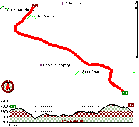
Trailhead 1 to Trailhead 2:
Total hiking length = 3 miles
Total climbing distance = 1.2 miles
Difficulty : Medium
Casual Hiking Pace: 2.5 hours
Fast Hiking Pace: 1.5 hours

Trailhead 2 to Trailhead 1:
Total hiking length = 3 miles
Total climbing distance = 1.3 miles
Difficulty : Medium
Casual Hiking Pace: 2.5 hours
Fast Hiking Pace: 1.5 hours
    Trailhead 1 back to Trailhead 1:
Total hiking length = 6 miles
Total climbing distance = 2.5 miles
Difficulty : Difficult
Casual Hiking Pace: 5.5 hours
Fast Hiking Pace: 3.5 hours

Trailhead 2 back to Trailhead 2:
Total hiking length = 6 miles
Total climbing distance = 2.5 miles
Difficulty : Difficult
Casual Hiking Pace: 5.5 hours
Fast Hiking Pace: 3.5 hours

Total elevation difference: 608 feet


Best Western Nova Plus Test Property, Test City
4 miles away
Property for administrative testing only. This is not a real hotel....
  
Best Western Msi Test Property, Test City
4 miles away
Property for administrative testing only. This is not a real hotel....
User input for Sierra Prieta Crest Trail Nmber Two Hundred Sixty Four, Yavapai County, Arizona:

Submit Input:
Your Name:
Write or Paste Input here:

Upload picture:      Review Guidelines


Outdoors Recreation Near Prescott, Arizona
Very comprehensive list of a variety of outdoors recreation in the vicinity of Prescott, Arizona, the metro area neareast to Sierra Prieta Crest Trail Nmber Two Hundred Sixty Four. Find info on campgrounds, hiking trails, ski resorts, lakes, beaches, parks, whitewater and more.

Current weather conditions at Sierra Prieta Crest Trail Nmber Two Hundred Sixty Four, Yavapai County, Arizona
WXPort

Local climate location: WALNUT CREEK 5 miles away

Comfort Inn at Ponderosa Pines, Prescott
6 miles away
The Comfort Inn of Prescott is nestled in the beautiful Ponderosa Pines. It borders the Prescott National Forest and is only 2 miles from downtown, which includes the Courthouse, Whiskey Row, Sharlot ...

Budget Host Sierra Inn, Prescott
6 miles away
Welcome to Budget Host Sierra Inn in Prescott-not far from Historic Prescott. Clean, comfortable accommodations feature one queen-size bed, two queen-size beds and one king-size bed. Ample amenities a...

More Hotels and Campgrounds Near Sierra Prieta Crest Trail Nmber Two Hundred Sixty Four, Yavapai County, Arizona

OTHER_INFO
  Arizona Hiking Trails
Complete list of all hiking trails in Arizona

Books about hiking trails in Arizona
List of books available on Amazon.com about hiking trails in Arizona.

Arizona Outdoors Index
This is a very comprehensive index of outdoors activities in the great state of Arizona.


TOPO
High quality water resistant topo map of Sierra Prieta Crest Trail Nmber Two Hundred Sixty Four, Yavapai County, Arizona.

OUTDOORS_GUIDE
These outdoors activities are available near Sierra Prieta Crest Trail Nmber Two Hundred Sixty Four.
 Trails Near Sierra Prieta Crest Trail Nmber Two Hundred Sixty Four:
Mount Francis Trail Forty Eight, Yavapai County , 4 miles away, 1.9 hiking miles, 1162 feet elevation difference
Little Granite Mountain Trail Number Thiry Seven, Yavapai County , 5 miles away,  10.2 hiking miles, 1392 feet elevation difference
Granite Mountain Trail Number Two Hundred Sixty One, Yavapai County , 6 miles away, 3.2 hiking miles, 588 feet elevation difference
Groom Creek Loop Trail, Yavapai County , 11 miles away, 7.7 hiking miles, 1353 feet elevation difference
Yankee Doodle Trail, Yavapai County , 14 miles away, 2.9 hiking miles, 1246 feet elevation difference
 Camp Grounds Near Sierra Prieta Crest Trail Nmber Two Hundred Sixty Four:
Emmanuel Pines Camp & Cnfrnc, Prescott, 3 miles away
Camp Charles Pearlstein, Prescott, 3 miles away
Saint Agatha Campground, Yavapai County, 5 miles away
Indian Creek Campground, Yavapai County, 6 miles away
White Spar Campground, Yavapai County, 6 miles away
 National Parks Near Sierra Prieta Crest Trail Nmber Two Hundred Sixty Four:
Montezuma Castle National Monument, Camp Verde - AZ , 50 miles away
Tuzigoot National Monument, Clarkdale - AZ , 50 miles away
 Hotels Near Sierra Prieta Crest Trail Nmber Two Hundred Sixty Four:
Best Western Nova Plus Test Property, Test City , 4 miles away
Best Western Msi Test Property, Test City , 4 miles away
Comfort Inn at Ponderosa Pines, Prescott , 6 miles away
Budget Host Sierra Inn, Prescott , 6 miles away
Hotel St. Michael, Prescott , 7 miles away
 Lakes Near Sierra Prieta Crest Trail Nmber Two Hundred Sixty Four
Prescott Reservoir, Yavapai County , 4 miles away

Outdoors related information copyright © Stratus-Pikpuk, Inc. - Detailed hotel information copyright © Interactive Hotel Solutions