Arizona hiking trails - Shingle Mill Mesa Thirty Five Trail, Graham County

   
  Shingle Mill Mesa Thirty Five Trail is a wilderness trail pretty far from Safford, but you always have a nice time when you're backcountry hiking along it. Trekking here in Arizona is the pleasant thing to do. There are numerous backpacking trails in Arizona, and each one is lovely in its own way. Shingle Mill Mesa Thirty Five Trail is a very long hiking and backpacking trail with an average amount of climbing distance which makes this a very tough backpacking and hiking trail for advanced hikers looking for a nice challenge. This great outdoors trail has
    a total elevation difference of 3,225 feet which is higher than average. Time to get out, and breathe some fresh air, and Shingle Mill Mesa Thirty Five Trail in Graham County, Arizona is just the site. Sometimes this hiking trail gets really dry, so don’t forget to check for any
current fire restrictions before you go. Some parts of Shingle Mill Mesa Thirty Five Trail are much higher up than other parts of the hiking trail, and that means that some parts of the hiking trail could be very different from other parts of it. Great outdoors hiking trails are pleasant and plentiful in Arizona; one of them being Shingle Mill Mesa Thirty Five Trail in Graham County. Summertime highs at Shingle Mill Mesa Thirty Five Trail regularly tend to be in the 90's. When the night sets in temperatures descend down into the 70's. For the period of  
the winter this place gets highs in the 50's, and nighttime lows through the winter for Shingle Mill Mesa Thirty Five Trail tend to be in the 30's. This is a one trailhead great outdoors trail, so in and out is the way to backcountry trek it normally. And keep in mind that there could be temporary safety restrictions in place. This is one of many backpacking and hiking trails in the surrounding region. Arizona is an outstanding outdoors state. Keep in mind that this is a long hiking trail, so do pack enough food to last the whole trip. Shingle Mill Mesa Thirty Five Trail is 19.2 miles long; it's considered a longer trek. Shingle Mill Mesa Thirty Five Trail is pretty waterless generally; the month with most of the rain is August while June is generally the driest month. This hike should take you about 3 days, so make sure you've got all your overnight gear packed.

Briefly about the general area:
Dickey Spring is always fun to check out. Hells Hole Creek is a nice site to stop at; you ought to unquestionably dedicate some time to Oak Flat since you're here at Shingle Mill Mesa Thirty Five Trail.
If you came to camp Soldier Creek Campground is a nice place to do that, and a wooded vicinity nearby is Safford Ranger District. Shingle Mill Mesa Thirty Five Trail is delightful enough to spend more than a day at, Riggs Flat Campground is a delightful local campground, and you'll almost certainly meet some folks from Safford here. Now, you may assume that's a lot but there's even more exciting stuff to do here at Shingle Mill Mesa Thirty Five Trail. Visit Sand Wash while you're here at Shingle Mill Mesa Thirty Five Trail, and a splendid place to take a look at is Shingle Mill Canyon.
Do set aside some time for Bear Basin since you're here at Shingle Mill Mesa Thirty Five Trail, and do put some time aside to spend at Green Spring if you're here at Shingle Mill Mesa Thirty Five Trail.

Location of Trailhead: Latitude 32.8088, Longitude -109.8707
- - Directions and Road Map

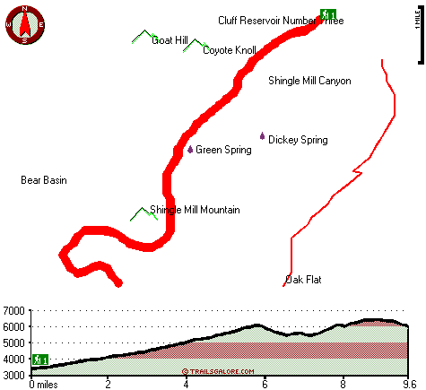
Total in and out hiking length = 19.2 miles

Total climbing distance = 9.1 miles

Difficulty : Difficult

Casual Hiking Pace: 3 days

Fast Hiking Pace: 2 days

Total elevation difference: 3225 feet


SpringHill Suites Thatcher, Thatcher
12 miles away
Fresh, stylish, new, and plugged in, the SpringHill Suites by Marriott? Thatcher-Safford hotel is perfect for your stay. At this hotel in Thatcher-Safford, AZ, you'll discover an energizing blend of ...
  
Comfort Inn & Suites Thatcher, Thatcher
12 miles away
Beautiful hotel nestled in the heart of the Gila Valley and built with the corporate traveler in mind. Get your work done in our business center or in the privacy of your room using your free WIFI and...
User input for Shingle Mill Mesa Thirty Five Trail, Graham County, Arizona:

Submit Input:
Your Name:
Write or Paste Input here:

Upload picture:      Review Guidelines


Outdoors Recreation Near Safford, Arizona
Very comprehensive list of a variety of outdoors recreation in the vicinity of Safford, Arizona, the metro area neareast to Shingle Mill Mesa Thirty Five Trail. Find info on campgrounds, hiking trails, ski resorts, lakes, beaches, parks, whitewater and more.

Current weather conditions at Shingle Mill Mesa Thirty Five Trail, Graham County, Arizona
WXPort

Local climate location: SAN CARLOS RESERVOIR 33 miles away

Super 8 Safford, Safford
13 miles away
Welcome to the Super 8 Safford, minutes from Roper Lake State Park. The Super 8 is located in the heart of Gila Valley in the Pinaleno or Graham Mountain Range. This Safford Super 8 is close to Rope...

Best Western Desert Inn, Safford
13 miles away
This Safford hotel features newly renovated guest rooms and great lodging in Graham County, Arizona. The Best Western Desert Inn offers beautiful mountain views as well as great amenities and custo...

More Hotels and Campgrounds Near Shingle Mill Mesa Thirty Five Trail, Graham County, Arizona

OTHER_INFO
  Arizona Hiking Trails
Complete list of all hiking trails in Arizona

Books about hiking trails in Arizona
List of books available on Amazon.com about hiking trails in Arizona.

Arizona Outdoors Index
This is a very comprehensive index of outdoors activities in the great state of Arizona.


TOPO
High quality water resistant topo map of Shingle Mill Mesa Thirty Five Trail, Graham County, Arizona.

OUTDOORS_GUIDE
These outdoors activities are available near Shingle Mill Mesa Thirty Five Trail.
 Trails Near Shingle Mill Mesa Thirty Five Trail:
Ash Creek Trail Three Hundred Seven, Graham County , 3 miles away, 7.4 hiking miles, 5955 feet elevation difference
Carter Canyon Number Thirty four Trail, Graham County , 5 miles away,  8.4 hiking miles, 2392 feet elevation difference
Grant Creek Three hundred five Trail, Graham County , 6 miles away,  10 hiking miles, 4569 feet elevation difference
Clark Park Trail Three hundred one, Graham County , 6 miles away,  2.8 hiking miles, 524 feet elevation difference
Jesus Goudy Ridge Trail Two hundred ninety eight, Graham County , 7 miles away, 7 hiking miles, 4669 feet elevation difference
Round the Mountain Trail, Graham County , 8 miles away, 6 hiking miles, 2610 feet elevation difference
Noon Creek Trail, Graham County , 9 miles away, 4.3 hiking miles, 2117 feet elevation difference
 Camp Grounds Near Shingle Mill Mesa Thirty Five Trail:
Soldier Creek Campground, Graham County, 4 miles away
Riggs Flat Campground, Graham County, 5 miles away
Hospital Flat Campground, Graham County, 7 miles away
Shannon Campground, Graham County, 8 miles away
Arcadia Campground, Graham County, 10 miles away
 National Parks Near Shingle Mill Mesa Thirty Five Trail:
Chiricahua National Monument, Willcox - AZ , 24 miles away
Fort Bowie National Historic Site, Willcox - AZ , 54 miles away
 Hotels Near Shingle Mill Mesa Thirty Five Trail:
SpringHill Suites Thatcher, Thatcher , 12 miles away
Comfort Inn & Suites Thatcher, Thatcher , 12 miles away
Super 8 Safford, Safford , 13 miles away
Best Western Desert Inn, Safford , 13 miles away
Econo Lodge Safford, Safford , 14 miles away

Outdoors related information copyright © Stratus-Pikpuk, Inc. - Detailed hotel information copyright © Interactive Hotel Solutions