| |
This trail goes to the top of Mt. Baldy, the second-highest peak in Arizona. It is 7 miles one way, 14 miles round trip. There is NO campground called Sheep's Crossing any more. You can camp at Big Lake, or at Winn Campground. Also, there is NO access in winter except on snowshoes, cross country skis or via snowmobile. The gates are closed, usually right up to just before Memorial Day weekend. It would be a very long walk indeed to get there. Says Elizabeth
West Baldy Trail has only one trailhead, so you'll be hiking it in and back out. The time needed for this hike is roughly 8.5 hours, but you never know stuff could go wrong and you could get stuck so be prepared for that. Keep in mind that this is a long wilderness hiking trail, so make sure you bring plenty of supplies. This backcountry trail goes through some very different elevations, and that means that some parts of the backcountry trail could be very different from other parts of it. West Baldy Trail is 10 miles long; it's longer than many backcountry trails. West Baldy Trail has a total elevation difference of 1,996 feet which is about average. At parts of the year this neighborhood sees very little rain, so don’t forget to check for any current fire restrictions before you go.
|
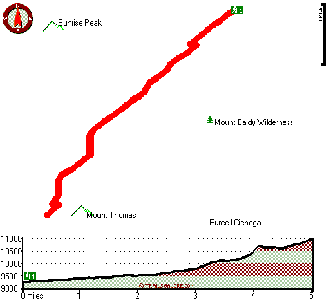
Total in and out hiking length = 10 miles
Total climbing distance = 3.9 miles
Difficulty : Difficult
Casual Hiking Pace:
8.5 hours
Fast Hiking Pace:
5.5 hours
Total elevation difference: 1996 feet
|


