Arizona hiking trails - Second Water Trail, Maricopa County

   
  Trekking in Arizona never gets boring. In Arizona you never run out of outdoors fun. It's a long drive from Payson to Second Water Trail, but it is an amusing spot to backcountry trek. The total elevation difference for Second Water Trail is 534 feet, and that is lower than average. Sometimes this hiking and backpacking trail gets really dry, so make sure you check current conditions and fire restrictions with local forest authorities before you head out. Hitting the backcountry trails is always an amusing thing to do, and if you happen to be in Maricopa County
    of Arizona, Second Water Trail is an outstanding local backcountry trail for doing a bit of leg stretching. Second Water Trail is a normal length great outdoors hiking trail with an average amount of climbing distance which makes it a nice great outdoors hiking trail for experienced
backcountry walkers in fine shape. There are great outdoors trails all over Arizona; Second Water Trail in Maricopa County is one of them. With its 6 miles of walking distance it's an average length hiking and backpacking trail. The hiking and backpacking trail stays roughly within the same elevation zone the whole time, so you get pretty much the same conditions along the whole hiking and backpacking trail. There is only one trailhead, so in and out is the way to hike it normally. Through the days of summer here at Second Water Trail, high temperatures ordinarily  
get into the 100's, and throughout the night it cools down to the 70's. Daytime highs throughout the wintertime are in the 60's while the cold winter nights at Second Water Trail are in the 30's. And keep in mind that there could be temporary safety restrictions in place. This walk shouldn't take more than 5 hours, but of course some folks walk a bit slower and some a bit faster. Second Water Trail gets very little precipitation; of all the months in a year March is the one with the most rain; the driest month is May. Each great outdoors trail in Arizona is different from the others. Second Water Trail is not that long but you should still bring some emergency supplies just in case something happens. This is just one of a large number of great outdoors hiking trails in this vicinity.

Briefly about the general area:
Second Water Canyon is near Second Water Trail and is a glorious place, and sites like Garden Valley are great to explore. Camping is available at Carney Springs Campground, and Mormon Flat is a good place.
Second Water Spring is always fun to check out, and La Barge Creek is in close proximity to Second Water Trail and is always a delight to go to. Hackberry Spring is a picturesque site to explore while you're at Second Water Trail, and some nearby water includes Tortilla Creek. If you want a splendid time in the great outdoors, just come on down to Second Water Trail. Glide down the rapids of Salt River in a kayak, and camping at Lost Dutchman State Park is always a brilliant experience.

Location of Trailhead: Latitude 33.4747, Longitude -111.4357
- - Directions and Road Map

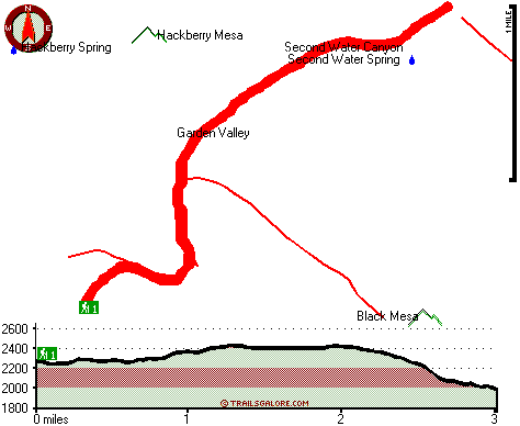
Total in and out hiking length = 6 miles

Total climbing distance = 2.3 miles

Difficulty : Difficult

Casual Hiking Pace: 5 hours

Fast Hiking Pace: 3.5 hours

Total elevation difference: 534 feet


Gold Canyon Golf Resort, Gold Canyon
8 miles away
The resorts 85 unique Casitas offer a variety of amenities such as Indoor or Outdoor Spas, Suites, Wood Burning Fireplaces, and Private Patios with splendid views of the majestic Superstition Mountain...
  
Best Western Gold Canyon Inn & Suites, Gold Canyon
9 miles away
Discover this Gold Canyon hotel located next to the Superstition Mountains and offering a complimentary continental breakfast. Whether traveling on business or for pleasure, the Best Western Gold Can...
User input for Second Water Trail, Maricopa County, Arizona:

Submit Input:
Your Name:
Write or Paste Input here:

Upload picture:      Review Guidelines


Outdoors Recreation Near Payson, Arizona
Very comprehensive list of a variety of outdoors recreation in the vicinity of Payson, Arizona, the metro area neareast to Second Water Trail. Find info on campgrounds, hiking trails, ski resorts, lakes, beaches, parks, whitewater and more.

Current weather conditions at Second Water Trail, Maricopa County, Arizona
WXPort

Local climate location: BARTLETT DAM 2 miles away

Super 8 Motel - Apache Junction, Apache Junction
10 miles away
* AAA Approved/2 Diamonds * Complimentary SuperStart Breakfast * Wireless high speed internet in all rooms * MicroFridge, in-room coffee makers, hair dryers, 27 ' cable TV w/HBO * Located a...

Best Western Apache Junction Inn, Apache Junction
11 miles away
This Apache Junction hotel just outside of Phoenix offers great accommodations and the beautiful scenery of the Superstition Mountains. The Best Western Apache Junction Inn is conveniently located w...

More Hotels and Campgrounds Near Second Water Trail, Maricopa County, Arizona

OTHER_INFO
  Arizona Hiking Trails
Complete list of all hiking trails in Arizona

Books about hiking trails in Arizona
List of books available on Amazon.com about hiking trails in Arizona.

Arizona Outdoors Index
This is a very comprehensive index of outdoors activities in the great state of Arizona.


TOPO
High quality water resistant topo map of Second Water Trail, Maricopa County, Arizona.

OUTDOORS_GUIDE
These outdoors activities are available near Second Water Trail.
 Trails Near Second Water Trail:
Black Mesa Trail, Maricopa County , 2 miles away,  8.2 hiking miles, 657 feet elevation difference
Boulder Trail, Maricopa County , 2 miles away,  13.6 hiking miles, 659 feet elevation difference
Red Hills Trail, Maricopa County , 3 miles away,  9.6 hiking miles, 502 feet elevation difference
West Boulder Trail, Pinal County , 4 miles away, 7.2 hiking miles, 1623 feet elevation difference
Needle Trail, Pinal County , 5 miles away,  9 hiking miles, 1203 feet elevation difference
Peralta Trail, Pinal County , 6 miles away,  11.2 hiking miles, 1340 feet elevation difference
Cave Trail, Pinal County , 6 miles away,  4.4 hiking miles, 1711 feet elevation difference
 Camp Grounds Near Second Water Trail:
Lost Dutchman State Park, Apache Junction, 5 miles away
Carney Springs Campground, Pinal County, 7 miles away
Peralta Canyon Campground, Pinal County, 8 miles away
Canyon Lake Marina And Campground, Apache Junction, 8 miles away
Canyon Vistas RV Resort, Apache Junction, 8 miles away
 Whitewater Near Second Water Trail:
Salt River, Gila County County , 14 miles away, Class -blank- - 12 miles long (Stewart Mountain Dam to Granite Reef Dam)
 National Parks Near Second Water Trail:
Tonto National Monument, Roosevelt - AZ , 30 miles away
Casa Grande Ruins National Monument, Coolidge - AZ , 31 miles away
Hohokam Pima National Monument, Coolidge - AZ , 31 miles away
 Hotels Near Second Water Trail:
Gold Canyon Golf Resort, Gold Canyon , 8 miles away
Best Western Gold Canyon Inn & Suites, Gold Canyon , 9 miles away
Super 8 Motel - Apache Junction, Apache Junction , 10 miles away
Best Western Apache Junction Inn, Apache Junction , 11 miles away
Arizona Golf Resort Hotel, Mesa , 19 miles away
 Lakes Near Second Water Trail
Canyon Lake, Maricopa County , 4 miles away

Outdoors related information copyright © Stratus-Pikpuk, Inc. - Detailed hotel information copyright © Interactive Hotel Solutions