Arizona hiking trails - Round the Mountain Trail, Graham County

   
  Spending too much time indoors got you down? No problem, Round the Mountain Trail in Graham County, Arizona is a nice selection. A visit to Arizona is not complete without some backcountry backpacking. A long trip separates Safford from Round the Mountain Trail, but backcountry trekking along this hiking trail is very fun. Every wilderness hiking trail in Arizona has its own character. Summertime highs at Round the Mountain Trail regularly tend to be in the 90's with nighttime lows in the 60's. The wintertime comes with highs in the 50's; nighttime lows
    at Round the Mountain Trail throughout the wintertime regularly fall into the 20's. It is very dried up here at Round the Mountain Trail usually; July is the month that gets the most rain, and May meanwhile is the driest month. This backpacking and hiking trail is many miles long
with an average amount of climbing distance which makes it a great wilderness trail for experienced walkers in good shape. Here in Arizona backcountry trekking is so much fun. This is just one of a large number of wilderness trails in this region. 
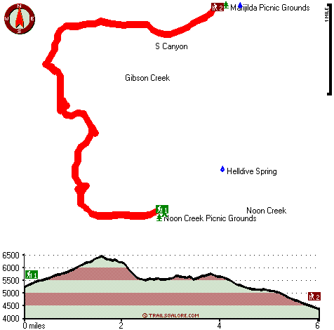
Round the Mountain Trail has a total elevation difference of 2,610 feet which is higher than average. Round the Mountain Trail is 12 miles long; it's a long backcountry trail. There are wilderness hiking trails all over Arizona; Round the Mountain Trail in Graham County is one of them. This is a long backcountry  
hiking trail, so do pack enough food to last the whole trip. At parts of the year this neighborhood sees very little rain, so don’t forget to check for any current fire restrictions before you go. This backcountry trek should take you about 2 days, so better have big backpack to fit all the stuff you need. This is a two-ended wilderness hiking trail with two trailheads, so if you can get a ride from someone, you can walk it just one way. Different parts of this backcountry trail are at very different elevations which of course means you need to be prepared for different conditions on different parts of the backcountry trail. Please follow all local rules about fires and camping.

Briefly about the general area:
It's always pleasant to explore Round the Mountain Spring, and if you came to camp Wet Canyon Campground is a wonderful spot to do that. At Round the Mountain Trail you always meet someone from Safford, and it's a tremendous idea to take a look at Crazy Horse Creek.
If you're here, you might as well stop at S Canyon, and you ought to undeniably dedicate some time to Snow Flat since you're here at Round the Mountain Trail. There's a forest here at Round the Mountain Trail called Safford Ranger District. There's so much to do here at Round the Mountain Trail that you need to camp here for a while, Noon Creek Campground is a tremendous place for that.
So much amusing stuff to do at Round the Mountain Trail, so little time. Why not pop by close by Gibson Creek since you're here at Round the Mountain Trail, and don't miss out on a journey to Chiricahua National Monument while you're here. Slick Rock Spring is a glorious local attraction, and a magnificent spot like Adams Flat here at Round the Mountain Trail is too great to miss.

Location of Trailhead 1: Latitude 32.6686, Longitude -109.7969
- - Directions and Road Map

Location of Trailhead 2: Latitude 32.7006, Longitude -109.7882
- - Directions and Road Map


Trailhead 1 to Trailhead 2:
Total hiking length = 6 miles
Total climbing distance = 2.4 miles
Difficulty : Difficult
Casual Hiking Pace: 5 hours
Fast Hiking Pace: 3 hours

Trailhead 2 to Trailhead 1:
Total hiking length = 6 miles
Total climbing distance = 3.2 miles
Difficulty : Difficult
Casual Hiking Pace: 5.5 hours
Fast Hiking Pace: 3 hours
    Trailhead 1 back to Trailhead 1:
Total hiking length = 12 miles
Total climbing distance = 5.6 miles
Difficulty : Difficult
Casual Hiking Pace: 2 days
Fast Hiking Pace: 7 hours

Trailhead 2 back to Trailhead 2:
Total hiking length = 12 miles
Total climbing distance = 5.6 miles
Difficulty : Difficult
Casual Hiking Pace: 2 days
Fast Hiking Pace: 7 hours

Total elevation difference: 2610 feet


Super 8 Safford, Safford
10 miles away
Welcome to the Super 8 Motel Safford, minutes from Roper Lake State Park. The Super 8 is located in the heart of Gila Valley in the Pinaleno or Graham Mountain Range. This Safford hotel is close to ...
  
Best Western Desert Inn, Safford
10 miles away
This Safford hotel features newly renovated guest rooms and great lodging in Graham County, Arizona. The Best Western Desert Inn offers beautiful mountain views as well as great amenities and custo...
User input for Round the Mountain Trail, Graham County, Arizona:

Submit Input:
Your Name:
Write or Paste Input here:

Upload picture:      Review Guidelines


Outdoors Recreation Near Safford, Arizona
Very comprehensive list of a variety of outdoors recreation in the vicinity of Safford, Arizona, the metro area neareast to Round the Mountain Trail. Find info on campgrounds, hiking trails, ski resorts, lakes, beaches, parks, whitewater and more.

Current weather conditions at Round the Mountain Trail, Graham County, Arizona
WXPort

Local climate location: SAFFORD AGR CTR 30 miles away

Quality Inn & Suites, Safford
11 miles away
Corporate and groups welcome. Indoor pool, whirlpool tub, and saunas. FREE high speed internet access. Data ports. Airport shuttle. Interior corridors with elevator. Restaurant, lounge, conference, gi...

Safford Days Inn, Safford
11 miles away
The Days Inn Safford, Arizona is a Chairman Award property, this is the highest award given by Days Inn for quality. We are located on Highway 70 in the Gila Valley with beautiful mountain views. We...

More Hotels and Campgrounds Near Round the Mountain Trail, Graham County, Arizona

OTHER_INFO
  Arizona Hiking Trails
Complete list of all hiking trails in Arizona

Books about hiking trails in Arizona
List of books available on Amazon.com about hiking trails in Arizona.

Arizona Outdoors Index
This is a very comprehensive index of outdoors activities in the great state of Arizona.


TOPO
High quality water resistant topo map of Round the Mountain Trail, Graham County, Arizona.

OUTDOORS_GUIDE
These outdoors activities are available near Round the Mountain Trail.
 Trails Near Round the Mountain Trail:
Noon Creek Trail, Graham County , 2 miles away, 4.3 hiking miles, 2117 feet elevation difference
Lady Bug Trail Three Hundred Twenty Nine, Graham County , 3 miles away,  8.6 hiking miles, 4205 feet elevation difference
Bear Canyon Two hundred ninety-nine Trail, Graham County , 5 miles away, 4.6 hiking miles, 3955 feet elevation difference
Dutch Henry Two hundred ninety seven Trail, Graham County , 5 miles away,  10.4 hiking miles, 4835 feet elevation difference
Ash Creek Trail Three Hundred Seven, Graham County , 6 miles away, 7.4 hiking miles, 5955 feet elevation difference
Grant Creek Three hundred five Trail, Graham County , 8 miles away,  10 hiking miles, 4569 feet elevation difference
Shingle Mill Mesa Thirty Five Trail, Graham County , 8 miles away,  19.2 hiking miles, 3225 feet elevation difference
 Camp Grounds Near Round the Mountain Trail:
Noon Creek Campground, Graham County, 2 miles away
Wet Canyon Campground, Graham County, 2 miles away
Arcadia Campground, Graham County, 2 miles away
Shannon Campground, Graham County, 4 miles away
Hospital Flat Campground, Graham County, 4 miles away
 National Parks Near Round the Mountain Trail:
Chiricahua National Monument, Willcox - AZ , 20 miles away
Fort Bowie National Historic Site, Willcox - AZ , 45 miles away
 Hotels Near Round the Mountain Trail:
Super 8 Safford, Safford , 10 miles away
Best Western Desert Inn, Safford , 10 miles away
Quality Inn & Suites, Safford , 11 miles away
Safford Days Inn, Safford , 11 miles away
Willcox Super 8 Motel, Willcox , 25 miles away
 Lakes Near Round the Mountain Trail
Frye Mesa Reservoir, Graham County , 4 miles away
Lebanon Reservoir Number One, Graham County , 5 miles away

Outdoors related information copyright © Stratus-Pikpuk, Inc. - Detailed hotel information copyright © Interactive Hotel Solutions