Arizona hiking trails - Red Tanks Trail, Pinal County

   
  Here in the delightful state of Arizona backcountry backpacking is a glorious way to spend some time. You'll need to go far from Payson to get to Red Tanks Trail, but if you're looking for a glorious place to go backcountry backpacking, this is a glorious pick. There are so many delightful hiking trails for backcountry backpacking in Arizona; one of these is Red Tanks Trail in Pinal County. Spending too much time indoors got you down? No problem, Red Tanks Trail in Pinal County, Arizona is such a glorious place. Each one of the many hiking trails of Arizona
    has something unique to offer. This vicinity does get very dry sometimes, so do check for current fire restrictions before you go if you plan to bring a stove or make a camp fire. Arizona has so much to offer the wilderness lovers. Red Tanks Trail is a one trailhead trail, so you'll
be hiking it in and back out. Red Tanks Trail is 24.4 miles long; it's longer than many backpacking and hiking trails. This trail has a total elevation difference of 1,305 feet, and that is about average. For the period of the days of summer, highs usually are in the 100's at Red Tanks Trail while overnight lows are ordinarily in the 70's. Daytime highs through the wintertime are in the 60's with winter lows in the 40's overnight here at Red Tanks Trail. Red Tanks Trail is quite long, so don't forget to pack enough supplies. This is one of many backcountry  
trails in the surrounding vicinity. Don’t forget to check for any current restrictions or closures before you go. This walk should take you about 3.5 days, so better have big backpack to fit all the stuff you need. Around Red Tanks Trail you don’t get a lot of precipitation; of all the months in a year August is the one with the most rain while June is usually the driest month. There's not much difference in elevation along the backpacking and hiking trail which means the conditions are about the same from start to finish. Red Tanks Trail is a great outdoors trail of pleasant length with an average amount of climbing distance which makes this a very tough backcountry trail for advanced backcountry hikers looking for a great challenge.

Briefly about the general area:
Cedar Basin is a delightful site; of course, A spree to Red Tanks Divide is always fun. If you have a thing about the outdoors, you'll like Red Tanks Trail. Peralta Canyon Campground is a great campground nearby, and some close by water includes Lewis and Pranty Creek.
Coffee Flat is a splendid place to check out, and don't leave Red Tanks Trail without first paying a visit to Labarge Spring Number Two. Gila River has a splendid whitewater paddling spot close by, and Canyon Spring is an inspiring spot to have a look at during your stay. Milk Ranch Creek is one of the streams close by that might be worth visiting, and Red Tanks Trail is a great site to visit for more than one day, Carney Springs Campground is a great site to camp nearby.

Location of Trailhead: Latitude 33.3981, Longitude -111.3469
- - Directions and Road Map

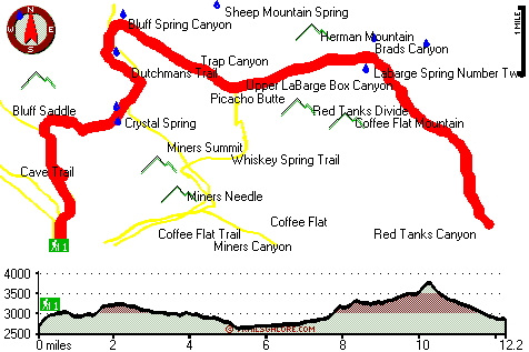
Total in and out hiking length = 24.4 miles

Total climbing distance = 10.8 miles

Difficulty : Difficult

Casual Hiking Pace: 3.5 days

Fast Hiking Pace: 2.5 days

Total elevation difference: 1305 feet


Gold Canyon Golf Resort, Gold Canyon
13 miles away
The resorts 85 unique Casitas offer a variety of amenities such as Indoor or Outdoor Spas, Suites, Wood Burning Fireplaces, and Private Patios with splendid views of the majestic Superstition Mountain...
  
Best Western Gold Canyon Inn & Suites, Gold Canyon
14 miles away
Discover this Gold Canyon hotel located next to the Superstition Mountains and offering a complimentary continental breakfast. Whether traveling on business or for pleasure, the Best Western Gold Can...
User input for Red Tanks Trail, Pinal County, Arizona:

Submit Input:
Your Name:
Write or Paste Input here:

Upload picture:      Review Guidelines


Outdoors Recreation Near Payson, Arizona
Very comprehensive list of a variety of outdoors recreation in the vicinity of Payson, Arizona, the metro area neareast to Red Tanks Trail. Find info on campgrounds, hiking trails, ski resorts, lakes, beaches, parks, whitewater and more.

Current weather conditions at Red Tanks Trail, Pinal County, Arizona
WXPort

Local climate location: MORMON FLAT 5 miles away

Apache Junction Super 8 Motel, Apache Junction
19 miles away
* AAA Approved/2 Diamonds * Complimentary SuperStart Breakfast * Wireless high speed internet in all rooms * MicroFridge, in-room coffee makers, hair dryers, 27 ' cable TV w/HBO * Located a...

Hyatt Place Phoenix Mesa, Mesa
19 miles away
Located in Mesa's new Riverview Center, adjacent to the Bass Pro Store, retauraurants and stores. Hyatt Place is a new kind of hotel that puts style, innovation and The Hyatt Touch? within everyone's...

More Hotels and Campgrounds Near Red Tanks Trail, Pinal County, Arizona

OTHER_INFO
  Arizona Hiking Trails
Complete list of all hiking trails in Arizona

Books about hiking trails in Arizona
List of books available on Amazon.com about hiking trails in Arizona.

Arizona Outdoors Index
This is a very comprehensive index of outdoors activities in the great state of Arizona.


TOPO
High quality water resistant topo map of Red Tanks Trail, Pinal County, Arizona.

OUTDOORS_GUIDE
These outdoors activities are available near Red Tanks Trail.
 Trails Near Red Tanks Trail:
Coffee Flat Trail, Pinal County , 3 miles away,  18.2 hiking miles, 930 feet elevation difference
Whiskey Spring Trail, Pinal County , 3 miles away,  10.8 hiking miles, 1127 feet elevation difference
J F Ranch Trail, Pinal County , 4 miles away,  15.8 hiking miles, 1409 feet elevation difference
Peters Trail, Maricopa County , 4 miles away,  13 hiking miles, 1423 feet elevation difference
Dutchmans Trail, Pinal County , 4 miles away, 15 hiking miles, 1029 feet elevation difference
Cave Trail, Pinal County , 6 miles away,  4.4 hiking miles, 1711 feet elevation difference
Needle Trail, Pinal County , 7 miles away,  9 hiking miles, 1203 feet elevation difference
 Camp Grounds Near Red Tanks Trail:
Peralta Canyon Campground, Pinal County, 6 miles away
Carney Springs Campground, Pinal County, 7 miles away
Encore RV Park-queen Valley, Apache Junction, 8 miles away
Queen Valley RV Resort, Apache Junction, 8 miles away
Apache Lake Campground, Maricopa County, 9 miles away
 Whitewater Near Red Tanks Trail:
Gila River, Pinal County County , 22 miles away, Class -blank- - 15 miles long (Kelvin to Ashurst-Hayden Dam)
Salt River, Gila County County , 25 miles away, Class -blank- - 12 miles long (Stewart Mountain Dam to Granite Reef Dam)
Verde River, Maricopa County County , 30 miles away, Class I-II - 19 miles long (Bartlett Reservoir to confluence with Salt River)
Tonto Creek, Gila County County , 33 miles away, Class IV(V) - 2 miles long (Box)
Verde River, Yavapai / Maricopa County County , 40 miles away, Class I-II - 19 miles long (Horseshoe Reservoir to Bartlett Reservoir)
 National Parks Near Red Tanks Trail:
Tonto National Monument, Roosevelt - AZ , 22 miles away
Casa Grande Ruins National Monument, Coolidge - AZ , 31 miles away
Hohokam Pima National Monument, Coolidge - AZ , 31 miles away
 Hotels Near Red Tanks Trail:
Gold Canyon Golf Resort, Gold Canyon , 13 miles away
Best Western Gold Canyon Inn & Suites, Gold Canyon , 14 miles away
Apache Junction Super 8 Motel, Apache Junction , 19 miles away
Hyatt Place Phoenix Mesa, Mesa , 19 miles away
Best Western Apache Junction Inn, Apache Junction , 20 miles away

Outdoors related information copyright © Stratus-Pikpuk, Inc. - Detailed hotel information copyright © Interactive Hotel Solutions