Arizona hiking trails - Raspberry Trail Thirty-five, San Francisco Mountains, Greenlee County

   
  There are many great backcountry trails in Arizona, and among these are Raspberry Trail Thirty-five in Greenlee County. Each backcountry trail in Arizona has its own character. Quite far from Safford you come upon Raspberry Trail Thirty-five, but hiking along this wilderness trail is very cool. Raspberry Trail Thirty-five has two trailheads, so if you can get a ride from someone, you can hike it just one way. Around Raspberry Trail Thirty-five you don’t get a lot of rainfall; during the month of August you get the most rain around here; May on the other
    hand is the driest. This area does get very dry sometimes, so make sure you check current conditions and fire restrictions with local forest authorities before you head out. Different parts of Raspberry Trail Thirty-five are at very different elevations, and that means that some
parts of the backpacking and hiking trail could be very different from other parts of it. This is a neighborhood covered with lots of wilderness hiking trails. Wilderness hiking trails like this one here in the San Francisco Mountains are a nice way to explore these mountaintops. This is a long hiking and backpacking trail, so don't forget to pack enough supplies. With its 16.2 miles of walking distance; it's a long backpacking and hiking trail. Here in the great state of Arizona trekking is a magnificent way to spend some time. The length of Raspberry  
Trail Thirty-five is on the longer side having an average number of uphill miles which makes this a very tough wilderness hiking trail for advanced trekkers looking for a magnificent challenge. Backcountry backpacking here in Arizona is a must. Alright, enough of spending all this time inside a building, time to get out, and Raspberry Trail Thirty-five in Greenlee County, Arizona is just what you need. Throughout the long summer days at Raspberry Trail Thirty-five highs are mostly in the 70's with nighttime lows in the 40's. The cold days of the wintertime come with highs in the 40's while the cold winter nights at Raspberry Trail Thirty-five are in the 10's. And keep in mind that there could be temporary safety restrictions in site. Now, this is roughly a 2.5-day backcountry hike, so it's an excellent thing if your backpack is big enough to do the job. This hiking trail has a total elevation difference of 3,036 feet, and that is higher than average.

Briefly about the general area:
You just can't picture the amount of outdoors fun stuff the San Francisco Mountains has to offer. A great location like Raspberry Basin here at Raspberry Trail Thirty-five is too splendid to miss, and Little Strayhorse Creek is close to Raspberry Trail Thirty-five and is always a pleasure to stop by. And that's not all you can do here at Raspberry Trail Thirty-five. Some nearby water includes McKittrick Creek, and don't leave Raspberry Trail Thirty-five without first paying a visit to Lengthy Spring.
Why not camp at KP Cienega Campground if you're here at Raspberry Trail Thirty-five; a perfect place for whitewater paddling is Blue River. While staying at Raspberry Trail Thirty-five you could always discover Grapevine Canyon, and camping is available at Stray Horse Campground. Having a fine time in the San Francisco Mountains is trouble-free. In case you don’t have a problem getting covered with water, you can always go whitewater paddling on Black River - East Fork.
You ought to definitely dedicate some time to Rattlesnake Basin while you're here at Raspberry Trail Thirty-five It's always brilliant to stop at Lengthy Spring.

Location of Trailhead 1: Latitude 33.5011, Longitude -109.2099
- - Directions and Road Map

Location of Trailhead 2: Latitude 33.5416, Longitude -109.3153
- - Directions and Road Map


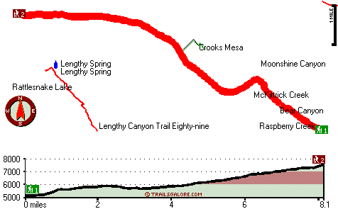
Trailhead 1 to Trailhead 2:
Total hiking length = 8.1 miles
Total climbing distance = 5.5 miles
Difficulty : Difficult
Casual Hiking Pace: 8.5 hours
Fast Hiking Pace: 5 hours

Trailhead 2 to Trailhead 1:
Total hiking length = 8.1 miles
Total climbing distance = 1.3 miles
Difficulty : Difficult
Casual Hiking Pace: 6 hours
Fast Hiking Pace: 3 hours
    Trailhead 1 back to Trailhead 1:
Total hiking length = 16.2 miles
Total climbing distance = 6.8 miles
Difficulty : Difficult
Casual Hiking Pace: 2.5 days
Fast Hiking Pace: 1.5 days

Trailhead 2 back to Trailhead 2:
Total hiking length = 16.2 miles
Total climbing distance = 6.8 miles
Difficulty : Difficult
Casual Hiking Pace: 2.5 days
Fast Hiking Pace: 1.5 days

Total elevation difference: 3036 feet


Best Western Sunrise Inn, Eagar
34 miles away
Located in Arizona's scenic White Mountains, this Eagar, Arizona hotel prides itself on superior customer service and is close to Sunrise Ski Resort. Situated on Main Street in Eagar, the Best Weste...
  
Americas Best Value Inn-Springerville, Springerville
35 miles away
Nestled on the edge of the majestic Apache National Forest and the foothills of the picturesque White Mountains, Americas Best Value Inn is ideally situated. Proudly offering value and amenities such ...
User input for Raspberry Trail Thirty-five, San Francisco Mountains, Greenlee County, Arizona:

Submit Input:
Your Name:
Write or Paste Input here:

Upload picture:      Review Guidelines


Outdoors Recreation Near Safford, Arizona
Very comprehensive list of a variety of outdoors recreation in the vicinity of Safford, Arizona, the metro area neareast to Raspberry Trail Thirty-five. Find info on campgrounds, hiking trails, ski resorts, lakes, beaches, parks, whitewater and more.

Current weather conditions at Raspberry Trail Thirty-five, San Francisco Mountains, Greenlee County, Arizona
WXPort

Local climate location: ALPINE 12 miles away


More Hotels and Campgrounds Near Raspberry Trail Thirty-five, San Francisco Mountains, Greenlee County, Arizona

OTHER_INFO
  San Francisco Mountains Campgrounds
Complete list of all the campgrounds in the San Francisco Mountains.

San Francisco Mountains Outdoors Info
Complete outdoors info for the San Francisco Mountains.

Arizona Hiking Trails
Complete list of all hiking trails in Arizona

Books about hiking trails in Arizona
List of books available on Amazon.com about hiking trails in Arizona.

Arizona Outdoors Index
This is a very comprehensive index of outdoors activities in the great state of Arizona.


TOPO
High quality water resistant topo map of Raspberry Trail Thirty-five, San Francisco Mountains, Greenlee County, Arizona.

OUTDOORS_GUIDE
These outdoors activities are available near Raspberry Trail Thirty-five.
 Trails Near Raspberry Trail Thirty-five:
Stray Horse Canyon Trail Twenty, Greenlee County , 2 miles away,  13.6 hiking miles, 894 feet elevation difference
Lengthy Canyon Trail Eighty-nine, Greenlee County , 2 miles away,  4.4 hiking miles, 1277 feet elevation difference
Steeple Mesa Seventy-Three Trail, Greenlee County , 4 miles away, 14.6 hiking miles, 2887 feet elevation difference
KP Trail Seventy, Greenlee County , 5 miles away,  15.2 hiking miles, 2663 feet elevation difference
Salt House Eighteen Trail, Greenlee County , 6 miles away,  6.4 hiking miles, 903 feet elevation difference
Crabtree Trail Twenty-two, Greenlee County , 6 miles away,  11.2 hiking miles, 1810 feet elevation difference
Red Mountain Twenty-five Trail, Greenlee County , 6 miles away,  13.4 hiking miles, 1871 feet elevation difference
 Camp Grounds Near Raspberry Trail Thirty-five:
Stray Horse Campground, Greenlee County, 4 miles away
KP Cienega Campground, Greenlee County, 7 miles away
Hannagan Campground, Greenlee County, 8 miles away
Blue Crossing Campground, Greenlee County, 13 miles away
Honeymoon Campground, Greenlee County, 16 miles away
 Whitewater Near Raspberry Trail Thirty-five:
Blue River, Greenlee County County , 6 miles away, Class IV-V - 34 miles long (Blue Crossing to Forest Service Road 475)
Black River - East Fork, Apache County County , 16 miles away, Class -blank- - 18 miles long (Diamond Rock to Wildcat Point)
San Francisco River, Greenlee County County , 22 miles away, Class -blank- - 40 miles long (Alma to Clifton)
San Francisco River, Catron County County , 25 miles away, Class II - 40 miles long (Lower San Francisco Hot Springs to Clifton Arizona)
San Francisco River, Catron County County , 31 miles away, Class II-III - 40 miles long (San Francisco to Pleasanton)
 Hotels Near Raspberry Trail Thirty-five:
Best Western Sunrise Inn, Eagar , 34 miles away
Americas Best Value Inn-Springerville, Springerville , 35 miles away

Outdoors related information copyright © Stratus-Pikpuk, Inc. - Detailed hotel information copyright © Interactive Hotel Solutions