| |
|
| | Alright, enough of spending all this time inside a building, time to get out, and Peralta Trail in Pinal County, Arizona is a great choice. When you're here in Arizona backcountry hiking along one of its backcountry hiking trails never gets boring. Each one of the many backcountry hiking trails of Arizona has its own character. This is a long hiking trail, so don't forget to pack enough supplies. Through the summertime months, highs commonly are in the 100's at Peralta Trail. Through the moonlight hours it's typically in the 70's. The winter comes with highs |
|
in the 60's while the cold winter nights at Peralta Trail are in the 30's. Peralta Trail has a total elevation difference of 1,340 feet which is an average number. Peralta Trail is a one trailhead hiking and backpacking trail, so you'll be backcountry hiking it in and back out.
| | There are backcountry hiking trails all over Arizona, and among these are Peralta Trail in Pinal County. This is an area covered with lots of backcountry trails. The length of Peralta Trail is on the longer side with an average amount of climbing distance which makes it a perfect backcountry trail for experienced backcountry walkers in glorious shape. And keep in mind that there could be temporary safety restrictions in spot. This neighborhood does get very dry sometimes, so don’t forget to check for any current fire restrictions before you go. With its | |
|
11.2 miles of walking distance; it's longer than many backcountry hiking trails. You spend the whole backcountry walk in roughly the same elevation zone which means the conditions are about the same from start to finish. A visit to Arizona is not complete without some backcountry
trekking. It is very dehydrated here at Peralta Trail regularly; of all the months in a year March is the one with the most rain; the driest of the months is May. This backcountry walk should take you about 1.5 days, so make sure you've got all your overnight gear packed. Peralta
Trail is a long tour away from Payson, but when you walk it you're always having a great time.
Briefly about the general area: A great place for whitewater paddling near Peralta Trail is Salt River; a great spot close by is Fremont Saddle. A pleasant tour to Marsh Valley
is a great way to spend an afternoon, and why not camp at Peralta Canyon Campground if you're here at Peralta Trail. Carney Spring is always fun to check out, and camping is available at Carney Springs Campground. You completely have to adore Peralta Trail. Horse Camp Basin
is a great place to stretch your legs a bit, and Bluff Spring Mountain Spring is a stunning spot to check out while you're at Peralta Trail.
|
|
Location of Trailhead: Latitude 33.3976, Longitude -111.3469 - - Directions and Road Map
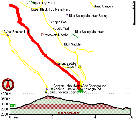
Total in and out hiking length = 11.2 miles
Total climbing distance = 5.2 miles
Difficulty : Difficult
Casual Hiking Pace:
1.5 days
Fast Hiking Pace:
6.5 hours
Total elevation difference: 1340 feet

Gold Canyon Golf Resort, Gold Canyon
|
6 miles away
The resorts 85 unique Casitas offer a variety of amenities such as Indoor or Outdoor Spas, Suites, Wood Burning Fireplaces, and Private Patios with splendid views of the majestic Superstition Mountain...
|
| |
Best Western Gold Canyon Inn & Suites, Gold Canyon
|
7 miles away
Discover this Gold Canyon hotel located next to the Superstition Mountains and offering a complimentary continental breakfast. Whether traveling on business or for pleasure, the Best Western Gold Can...
|
|
User input for Peralta Trail, Pinal County, Arizona:

Outdoors Recreation Near Payson, Arizona Very comprehensive list of a variety of outdoors recreation in the vicinity of Payson, Arizona, the metro area neareast to Peralta Trail. Find info on campgrounds, hiking trails, ski resorts, lakes, beaches, parks, whitewater and more.
More Hotels and Campgrounds Near Peralta Trail, Pinal County, Arizona
| |
| |
 |
|
| These outdoors activities are available near Peralta Trail. |
| | Trails Near Peralta Trail:
 |
Cave Trail, Pinal
County
, 1 miles away, 4.4 hiking miles, 1711 feet elevation difference |
 |
Needle Trail, Pinal
County
, 1 miles away, 9 hiking miles, 1203 feet elevation difference |
 |
West Boulder Trail, Pinal
County
, 2 miles away, 7.2 hiking miles, 1623 feet elevation difference |
 |
Dutchmans Trail, Pinal
County
, 3 miles away, 15 hiking miles, 1029 feet elevation difference |
 |
Red Hills Trail, Maricopa
County
, 3 miles away, 9.6 hiking miles, 502 feet elevation difference |
 |
Black Mesa Trail, Maricopa
County
, 4 miles away, 8.2 hiking miles, 657 feet elevation difference |
 |
Whiskey Spring Trail, Pinal
County
, 4 miles away, 10.8 hiking miles, 1127 feet elevation difference |
|
| | Whitewater Near Peralta Trail:
 |
Salt River, Gila County
County
, 18 miles away, Class -blank- - 12 miles long (Stewart Mountain Dam to Granite Reef Dam) |
|
| | National Parks Near Peralta Trail:
 |
Tonto National Monument, Roosevelt - AZ
, 28 miles away |
 |
Casa Grande Ruins National Monument, Coolidge - AZ
, 28 miles away |
 |
Hohokam Pima National Monument, Coolidge - AZ
, 28 miles away |
|
| | Hotels Near Peralta Trail:
 |
Gold Canyon Golf Resort, Gold Canyon
, 6 miles away |
 |
Best Western Gold Canyon Inn & Suites, Gold Canyon
, 7 miles away |
 |
Apache Junction Super 8 Motel, Apache Junction
, 12 miles away |
 |
Best Western Apache Junction Inn, Apache Junction
, 13 miles away |
 |
Hyatt Place Phoenix Mesa, Mesa
, 14 miles away |
|
|
|
 |
|