Arizona hiking trails - North Peak Trail, Mogollon Rim Mountains, Gila County

   
  Going for a trek here in Arizona is the glorious thing to do. You can't spend all your time indoors you need to get out once in a while, and if you happen to be in Gila County of Arizona, North Peak Trail is a splendid local trail for doing a bit of leg stretching. North Peak Trail is not very close to Payson at all, but there's brilliant natural prettiness waiting for you here along it. At North Peak Trail you don’t see much rainfall; of all the months in a year August is the one with the most rain; June meanwhile is the driest month. North Peak Trail
    is a normal length hiking trail having an average number of uphill miles which makes it a splendid hiking trail for experienced backcountry walkers in good shape. You should count on this hike taking about 7.5 hours, but you never know stuff could go wrong and you could get stuck
so be prepared for that. This is a one trailhead backcountry trail, so you'll be backcountry backpacking it in and back out. The gorgeous hiking trails of the Mogollon Rim Mountains are a really good way to spend quality time in nature. With its 8.2 miles of walking distance it's a mid length walk. Each hiking and backpacking trail in Arizona has its own character. The total elevation difference for North Peak Trail is 2,380 feet which is about average. This trail sometimes gets very dry, so don’t forget to check for any current fire restrictions before  
you go. Don’t forget to check for any current restrictions or closures before you go. This is a neighborhood covered with lots of hiking trails. There are many glorious hiking and backpacking trails in Arizona; one of them being North Peak Trail in Gila County. Now this trail is pretty long, so don't forget to pack enough supplies. Different parts of this great outdoors hiking trail are at very different elevations, so keep in mind that you may need to dress differently at different elevations. This part of Arizona has a splendid deal of available outdoors activities. Through the long summer days here at North Peak Trail, high temperatures ordinarily reach the 100's while nighttime lows are mostly in the 60's. The winter brings highs down to the 50's; nighttime lows at North Peak Trail during the winter mostly descend into the 30's.

Briefly about the general area:
So much amusing stuff to do here in the Mogollon Rim Mountains, too good to be true. Don't leave North Peak Trail without first paying a visit to Mineral Spring, and getting to Mineral Creek from North Peak Trail is simple. A pleasant spree to Simonton Flat is a fine way to spend an afternoon.
Tonto Creek has a magnificent whitewater paddling spot close by It's always good to stop by Dennis Spring. A splendid forest close to North Peak Trail is Cypress Thicket, and why not take a little visit to Hill Creek while you're here. Stay the night at Oxbow Estates RV Park, and in case you don’t mind getting wet, you can always go whitewater paddling on East Verde River.
All year is a wonderful time in the Mogollon Rim Mountains if you adore the outdoors. While you're here at North Peak Trail it's a good idea to go to The Park, and Montezuma Castle National Monument is a good spot nearby. Whohoo, so many cool things in one place! North Peak Trail rocks! You'll need more than a day to explore everything North Peak Trail has to offer, you can camp at Kool Oaks Trailer Park; a wonderful place is Hells Hole.

Location of Trailhead: Latitude 34.1775, Longitude -111.4481
- - Directions and Road Map

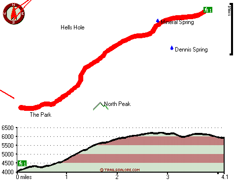
Total in and out hiking length = 8.2 miles

Total climbing distance = 3.5 miles

Difficulty : Difficult

Casual Hiking Pace: 7.5 hours

Fast Hiking Pace: 4.5 hours

Total elevation difference: 2380 feet


Paysonglo Lodge, Payson
11 miles away
Nestled among the majestic mountains of the Mogollon Rim lies a unique and serene Payson Arizona hotel: Paysonglo Lodge. The perfect spot for a Payson AZ hotel getaway. Here in Payson we offer more...
  
Days Inn And Suites Of Payson, Payson
11 miles away
Welcome to the Days Inn & Suites of Payson. When you are visiting Payson next, take refuge in this comfortable interior hotel. Experience the difference and we are sure you will make it your home aw...
User input for North Peak Trail, Mogollon Rim Mountains, Gila County, Arizona:

Submit Input:
Your Name:
Write or Paste Input here:

Upload picture:      Review Guidelines


Outdoors Recreation Near Payson, Arizona
Very comprehensive list of a variety of outdoors recreation in the vicinity of Payson, Arizona, the metro area neareast to North Peak Trail. Find info on campgrounds, hiking trails, ski resorts, lakes, beaches, parks, whitewater and more.

Current weather conditions at North Peak Trail, Mogollon Rim Mountains, Gila County, Arizona
WXPort

Local climate location: CHILDS 4 miles away

Pine Victorian Inn, Payson
11 miles away
We are a Pine Arizona bed and breakfast inn located near the town of Payson and are just minutes from Strawberry AZ. Located just three miles from the Tonto Natural Bridge State Park and a few miles ...

Holiday Inn Express Payson, Az, Payson
11 miles away
Payson is nestled among the Ponderosa pines and clean air of the Mogollon Rim. The Tonto Natural Bridge, camping, hiking, fishing, hunting and boating areas are a short drive away. The Holiday Inn Exp...

More Hotels and Campgrounds Near North Peak Trail, Mogollon Rim Mountains, Gila County, Arizona

OTHER_INFO
  Mogollon Rim Mountains Campgrounds
Complete list of all the campgrounds in the Mogollon Rim Mountains.

Mogollon Rim Mountains Outdoors Info
Complete outdoors info for the Mogollon Rim Mountains.

Arizona Hiking Trails
Complete list of all hiking trails in Arizona

Books about hiking trails in Arizona
List of books available on Amazon.com about hiking trails in Arizona.

Arizona Outdoors Index
This is a very comprehensive index of outdoors activities in the great state of Arizona.


TOPO
High quality water resistant topo map of North Peak Trail, Mogollon Rim Mountains, Gila County, Arizona.

OUTDOORS_GUIDE
These outdoors activities are available near North Peak Trail.
 Trails Near North Peak Trail:
Mazatzal Divide, Yavapai County , 4 miles away, 26.3 hiking miles, 4287 feet elevation difference
Barnhardt Trail, Gila County , 5 miles away,  11.6 hiking miles, 2143 feet elevation difference
Shake Tree Trail, Gila County , 6 miles away,  10.2 hiking miles, 2355 feet elevation difference
Willow Spring Trail, Yavapai County , 7 miles away,  34.2 hiking miles, 5105 feet elevation difference
Club Ranch Trail, Yavapai County , 8 miles away,  25 hiking miles, 3154 feet elevation difference
Table Mountain Trail, Yavapai County , 9 miles away,  27.2 hiking miles, 3116 feet elevation difference
 Camp Grounds Near North Peak Trail:
Oxbow Estates RV Park, Payson, 10 miles away
Kool Oaks Trailer Park, Payson, 10 miles away
Mountain Shadows Mobile Resort, Payson, 11 miles away
Payson Campground, Payson, 11 miles away
Flowing Springs Campground, Gila County, 11 miles away
 Whitewater Near North Peak Trail:
East Verde River, Gila County County , 8 miles away, Class V+ - 34 miles long (US Route 87 to Verde River confluence)
Tonto Creek, Gila County County , 15 miles away, Class IV(V) - 2 miles long (Box)
Verde River, Yavapai County County , 16 miles away, Class I-III - 25 miles long (Childs to Horseshoe Reservoir)
Verde River, Yavapai / Maricopa County County , 19 miles away, Class I-II - 19 miles long (Horseshoe Reservoir to Bartlett Reservoir)
 National Parks Near North Peak Trail:
Montezuma Castle National Monument, Camp Verde - AZ , 34 miles away
Tonto National Monument, Roosevelt - AZ , 45 miles away
Sunset Crater Volcano National Monument, Flagstaff - AZ , 62 miles away
 Hotels Near North Peak Trail:
Paysonglo Lodge, Payson , 11 miles away
Days Inn And Suites Of Payson, Payson , 11 miles away
Pine Victorian Inn, Payson , 11 miles away
Holiday Inn Express Payson, Az, Payson , 11 miles away
Best Western Payson Inn, Payson , 12 miles away

Outdoors related information copyright © Stratus-Pikpuk, Inc. - Detailed hotel information copyright © Interactive Hotel Solutions