| |
|
| | Arizona is a perfect place for walkers. There are so many splendid hiking trails for trekking in Arizona; one of those is Needle Trail in Pinal County. Backcountry trekking in Arizona is always an amusing thing to do. Hey, time for a backcountry hike don’t you think? Needle Trail in Pinal County, Arizona is a really glorious spot to spend some time. This neighborhood does get very dry sometimes, so don’t forget to check for any current fire restrictions before you go. Now this hiking trail is pretty long, so don't forget to pack enough supplies. The time |
|
needed for this backcountry walk is roughly 8 hours, but you never know stuff could go wrong and you could get stuck so be prepared for that. The total elevation difference for this great outdoors hiking trail is 1,203 feet, and that is about average. This is a region covered with
| | lots of great outdoors hiking trails. Needle Trail is a location that is pretty dried up typically; of all the months in a year March is the one with the most rain, and the driest month of the year is May. You spend the whole hike in roughly the same elevation zone, so you won’t have to worry about different climate zones along your hike. Rather far from Payson you run into Needle Trail, but backcountry trekking it is glorious enjoyment any time. Don’t forget to check for any current restrictions or closures before you go. Being 9 miles long it's a mid | |
|
length hike. Through the summertime, highs frequently are in the 100's at Needle Trail. During the dark hours of summer temperatures drop down into the 70's. The winter brings highs down to the 60's, and nighttime lows in the 30's for Needle Trail. There are numerous hiking trails
in Arizona, and each one is worth trekking. The length of this wilderness hiking trail is about average having an average number of uphill miles which makes this great outdoors hiking trail great for hard core backpackers looking for adventure. Needle Trail has only one trailhead,
so you'll be backpacking it in and back out.
Briefly about the general area: Don’t forget to stop at Marsh Valley if you're here at Needle Trail, and Terrapin Pass is another good site to check out nearby. At this river you will never have a bad time. A short visit to
White Rock Spring is always worthwhile, and camping is available at Peralta Canyon Campground. Bluff Spring Mountain Spring is a beautiful place to go to while you're at Needle Trail, and there are some delightful whitewater spots on Salt River. Do set aside some time for Horse
Camp Basin if you're here at Needle Trail; camping at Carney Springs Campground is always a brilliant experience. Not enough hours in a day to enjoy this place.
|
|
Location of Trailhead: Latitude 33.3976, Longitude -111.3471 - - Directions and Road Map
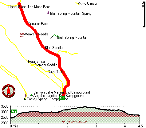
Total in and out hiking length = 9 miles
Total climbing distance = 4 miles
Difficulty : Difficult
Casual Hiking Pace:
8 hours
Fast Hiking Pace:
5.5 hours
Total elevation difference: 1203 feet

Gold Canyon Golf Resort, Gold Canyon
|
7 miles away
The resorts 85 unique Casitas offer a variety of amenities such as Indoor or Outdoor Spas, Suites, Wood Burning Fireplaces, and Private Patios with splendid views of the majestic Superstition Mountain...
|
| |
Best Western Gold Canyon Inn & Suites, Gold Canyon
|
8 miles away
Discover this Gold Canyon hotel located next to the Superstition Mountains and offering a complimentary continental breakfast. Whether traveling on business or for pleasure, the Best Western Gold Can...
|
|
User input for Needle Trail, Pinal County, Arizona:

Outdoors Recreation Near Payson, Arizona Very comprehensive list of a variety of outdoors recreation in the vicinity of Payson, Arizona, the metro area neareast to Needle Trail. Find info on campgrounds, hiking trails, ski resorts, lakes, beaches, parks, whitewater and more.
More Hotels and Campgrounds Near Needle Trail, Pinal County, Arizona
| |
| |
 |
|
| These outdoors activities are available near Needle Trail. |
| | Trails Near Needle Trail:
 |
Peralta Trail, Pinal
County
, 1 miles away, 11.2 hiking miles, 1340 feet elevation difference |
 |
Cave Trail, Pinal
County
, 2 miles away, 4.4 hiking miles, 1711 feet elevation difference |
 |
West Boulder Trail, Pinal
County
, 2 miles away, 7.2 hiking miles, 1623 feet elevation difference |
 |
Dutchmans Trail, Pinal
County
, 2 miles away, 15 hiking miles, 1029 feet elevation difference |
 |
Red Hills Trail, Maricopa
County
, 2 miles away, 9.6 hiking miles, 502 feet elevation difference |
 |
Black Mesa Trail, Maricopa
County
, 3 miles away, 8.2 hiking miles, 657 feet elevation difference |
 |
Boulder Trail, Maricopa
County
, 3 miles away, 13.6 hiking miles, 659 feet elevation difference |
|
| | Whitewater Near Needle Trail:
 |
Salt River, Gila County
County
, 18 miles away, Class -blank- - 12 miles long (Stewart Mountain Dam to Granite Reef Dam) |
|
| | National Parks Near Needle Trail:
 |
Tonto National Monument, Roosevelt - AZ
, 27 miles away |
 |
Casa Grande Ruins National Monument, Coolidge - AZ
, 29 miles away |
 |
Hohokam Pima National Monument, Coolidge - AZ
, 29 miles away |
|
| | Hotels Near Needle Trail:
 |
Kings Ranch Gold Canyon's Rnch., Apache Junction
, 6 miles away |
 |
Gold Canyon Golf Resort, Gold Canyon
, 7 miles away |
 |
Best Western Gold Canyon Inn & Suites, Gold Canyon
, 8 miles away |
 |
Palm Springs Motel, Apache Junction
, 12 miles away |
 |
Apache Junction Super 8 Motel, Apache Junction
, 13 miles away |
|
|
|
 |
|