Arizona hiking trails - Myrtle Trail, Mogollon Rim Mountains, Gila County

   
  Finally, trekking time is here again, and Myrtle Trail in Gila County, Arizona is just the place. Here in Arizona backcountry trekking is the perfect thing to do. Hiking trails are perfect and plentiful in Arizona, and Myrtle Trail in Gila County is one of them. These hiking and backpacking trails here in the Mogollon Rim Mountains are the best way to enjoy these mountains. The total elevation difference for this trail is 1,565 feet which is an average number. Sometimes this hiking trail gets really dry, so do check for current fire restrictions before
    you go if you plan to bring a stove or make a camp fire. This hiking and backpacking trail is a normal length hiking and backpacking trail having an average number of uphill miles which makes it a perfect wilderness trail for the average person looking for a perfect adventure.
Different parts of Myrtle Trail are at very different elevations, and that means that some parts of the great outdoors hiking trail could be very different from other parts of it. Myrtle Trail is a two ended trail with two trailheads which means you have the option of backcountry backpacking it one way if you have someone to pick you up at the other end. You should count on this trek taking about 4.5 hours, but you never know stuff could go wrong and you could get stuck so be prepared for that. There are so many wilderness trails in this area. The amount  
of rainfall that falls at Myrtle Trail is close to the national average; through August this neighborhood sees the most rain, and the driest month of the year is June. Even though this is not a very long hiking trail you should still bring some emergency supplies just in case something happens. Every single Arizona hiking and backpacking trail has its own unique prettiness. Summertime highs at Myrtle Trail ordinarily tend to be in the 90's, and through summer nights temperatures are in the 50's. For the period of the winter highs are in the 50's with temperatures at Myrtle Trail dipping down into the 20's through winter nights. With its 5.4 miles of walking distance it's a mid length trek. Myrtle Trail is a long drive away from Payson, but trekking it is good pleasure any time. If you are in Arizona during backcountry backpacking season you have to go backcountry backpacking. And keep in mind that there could be temporary safety restrictions in place.

Briefly about the general area:
Horton Campground is a splendid campground nearby. Turkey Spring is always fun to check out, and while you're here why not explore Hells Gate Canyon.
Man, is there plenty of fun things to do in the Mogollon Rim Mountains. A short visit to Barbershop Spring is always worthwhile; Knoll Lake Campground is a perfect local campground.

Location of Trailhead 1: Latitude 34.4063, Longitude -111.1764
- - Directions and Road Map

Location of Trailhead 2: Latitude 34.3974, Longitude -111.2005
- - Directions and Road Map


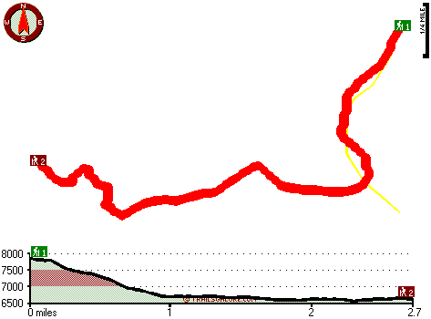
Trailhead 1 to Trailhead 2:
Total hiking length = 2.7 miles
Total climbing distance = .4 miles
Difficulty : Easy
Casual Hiking Pace: 2 hours
Fast Hiking Pace: 1 hours

Trailhead 2 to Trailhead 1:
Total hiking length = 2.7 miles
Total climbing distance = 1.5 miles
Difficulty : Medium
Casual Hiking Pace: 2.5 hours
Fast Hiking Pace: 1.5 hours
    Trailhead 1 back to Trailhead 1:
Total hiking length = 5.4 miles
Total climbing distance = 1.9 miles
Difficulty : Medium
Casual Hiking Pace: 4.5 hours
Fast Hiking Pace: 3 hours

Trailhead 2 back to Trailhead 2:
Total hiking length = 5.4 miles
Total climbing distance = 1.9 miles
Difficulty : Medium
Casual Hiking Pace: 4.5 hours
Fast Hiking Pace: 3 hours

Total elevation difference: 1565 feet


Super 8 Motel, Payson
13 miles away
The Super 8 is centrally located in Payson to enjoy local attractions like Christopher Creek. Free High Speed Internet Access Free Local Calls Outdoor Whirlpool/Hot Tub Outdoor Pool and Heated Spa Ext...
  
Best Western Payson Inn, Payson
13 miles away
**Hotel Pool and Hot Tub will be closed for the Winter season beginning November 1, 2008 to May 1, 2009** This full-service Payson, Arizona hotel offers a variety of amenities, a deluxe continental b...
User input for Myrtle Trail, Mogollon Rim Mountains, Gila County, Arizona:

Submit Input:
Your Name:
Write or Paste Input here:

Upload picture:      Review Guidelines


Outdoors Recreation Near Payson, Arizona
Very comprehensive list of a variety of outdoors recreation in the vicinity of Payson, Arizona, the metro area neareast to Myrtle Trail. Find info on campgrounds, hiking trails, ski resorts, lakes, beaches, parks, whitewater and more.

Current weather conditions at Myrtle Trail, Mogollon Rim Mountains, Gila County, Arizona
WXPort

Local climate location: PAYSON 14 miles away

Holiday Inn Express Payson, Az, Payson
14 miles away
Payson is nestled among the Ponderosa pines and clean air of the Mogollon Rim. The Tonto Natural Bridge, camping, hiking, fishing, hunting and boating areas are a short drive away. The Holiday Inn Exp...

Pine Victorian Inn, Payson
14 miles away
We are a Pine Arizona bed and breakfast inn located near the town of Payson and are just minutes from Strawberry AZ. Located just three miles from the Tonto Natural Bridge State Park and a few miles ...

More Hotels and Campgrounds Near Myrtle Trail, Mogollon Rim Mountains, Gila County, Arizona

OTHER_INFO
  Mogollon Rim Mountains Campgrounds
Complete list of all the campgrounds in the Mogollon Rim Mountains.

Mogollon Rim Mountains Outdoors Info
Complete outdoors info for the Mogollon Rim Mountains.

Arizona Hiking Trails
Complete list of all hiking trails in Arizona

Books about hiking trails in Arizona
List of books available on Amazon.com about hiking trails in Arizona.

Arizona Outdoors Index
This is a very comprehensive index of outdoors activities in the great state of Arizona.


TOPO
High quality water resistant topo map of Myrtle Trail, Mogollon Rim Mountains, Gila County, Arizona.

OUTDOORS_GUIDE
These outdoors activities are available near Myrtle Trail.
 Trails Near Myrtle Trail:
Highline Trail, Gila County , 3 miles away, 6.9 hiking miles, 2002 feet elevation difference
Horton Creek Trail, Gila County , 7 miles away, 8.8 hiking miles, 722 feet elevation difference
Hells Gate Trail, Gila County , 8 miles away, 9.5 hiking miles, 2084 feet elevation difference
Bear Flat Pleasant Valley Trail, Gila County , 13 miles away, 7.7 hiking miles, 1293 feet elevation difference
 Camp Grounds Near Myrtle Trail:
Knoll Lake Campground, Coconino County, 6 miles away
Horton Campground, Gila County, 7 miles away
Third Crossing Campground, Gila County, 7 miles away
Star Vale, Payson, 8 miles away
Second Crossing Campground, Gila County, 8 miles away
 National Parks Near Myrtle Trail:
Tonto National Monument, Roosevelt - AZ , 46 miles away
Montezuma Castle National Monument, Camp Verde - AZ , 47 miles away
Tuzigoot National Monument, Clarkdale - AZ , 47 miles away
 Hotels Near Myrtle Trail:
Super 8 Motel, Payson , 13 miles away
Best Western Payson Inn, Payson , 13 miles away
Holiday Inn Express Payson, Az, Payson , 14 miles away
Pine Victorian Inn, Payson , 14 miles away
Days Inn And Suites Of Payson, Payson , 14 miles away

Outdoors related information copyright © Stratus-Pikpuk, Inc. - Detailed hotel information copyright © Interactive Hotel Solutions