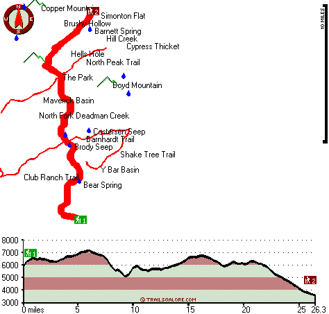
Arizona hiking trails - Mazatzal Divide, Mogollon Rim Mountains, Yavapai County

   
  Arizona has plenty of pleasant backcountry hiking trails, and Mazatzal Divide in Yavapai County is one of them. There are numerous backcountry hiking trails in Arizona, and each one has its own character. Backpacking in Arizona never gets boring. The warmest time of the year at Mazatzal Divide comes with high temperatures in the 100's while nighttime lows are commonly in the 60's. Highs through the wintertime are commonly in the 50's, and through the dark hours in the wintertime at Mazatzal Divide temperatures drop to the 30's. This is a backcountry trail
    that is quite long, so don't forget to pack enough supplies. With its 52.6 miles of walking distance; it's considered a longer trek. This hiking trail is a very long hiking trail with an average amount of climbing distance which makes this hiking and backpacking trail good for
hard core backpackers looking for adventure. These hiking trails here in the Mogollon Rim Mountains are a very good way to see these hills. Of course, this is an overnight trek, 8 days normally, so make sure you've got all your overnight gear packed. This great outdoors trail has a total elevation difference of 4,287 feet which is a higher than average number. Different parts of this backcountry hiking trail are at very different elevations which of course means you need to be prepared for different conditions on different parts of the backcountry hiking  
trail. Mazatzal Divide is a wilderness hiking trail quite far from Payson, but when you walk it you're always having a brilliant time. Don’t forget to check for any current restrictions or closures before you go. This great outdoors trail has two trailheads, so if you can get a ride from someone, you can walk it just one way. Put on your hiking shoes, and hit the wilderness hiking trail, Mazatzal Divide in Yavapai County, Arizona is such a brilliant site. Mazatzal Divide is ordinarily a quite arid location; August is when you get the most rain here, and June meanwhile is the driest month. This backcountry trail sometimes gets very dry, so make sure you check current conditions and fire restrictions with local forest authorities before you head out. Arizona is a glorious outdoors state. This is one of many hiking and backpacking trails in the surrounding neighborhood.

Briefly about the general area:
A great place to camp here at Mazatzal Divide is Kool Oaks Trailer Park, and as expected North Fork Deadman Creek flows through this region. Mazatzal Divide is fine enough to spend more than a day at, Oxbow Estates RV Park is a fine local campground.
A forest near Mazatzal Divide is Cypress Thicket; there's some flowing water nearby, Center Creek is a stream you can take a look at during your stay. East Verde River is a good whitewater spot in close proximity to Mazatzal Divide; why not check out Cat Bay also if you're here. Now, you may feel that's a lot but there's even more entertaining stuff to do here at Mazatzal Divide. Don’t forget to stop by The Park since you're here at Mazatzal Divide, and do put some time aside to spend at Chilson Spring while you're here at Mazatzal Divide.
You simply should love the Mogollon Rim Mountains. A wonderful location like Maverick Basin here at Mazatzal Divide is too great to miss, and if you don’t have a problem getting soaked, you can always go whitewater paddling on Tonto Creek. These mountains rock, just explore all the enjoyable stuff to do in the Mogollon Rim Mountains. Brody Seep is a good local attraction, and a splendid place to have a look at close by is Hells Hole.

Location of Trailhead 1: Latitude 33.9991, Longitude -111.4753
- - Directions and Road Map

Location of Trailhead 2: Latitude 34.2164, Longitude -111.4623
- - Directions and Road Map


Trailhead 1 to Trailhead 2:
Total hiking length = 26.3 miles
Total climbing distance = 10.1 miles
Difficulty : Difficult
Casual Hiking Pace: 4 days
Fast Hiking Pace: 2 days

Trailhead 2 to Trailhead 1:
Total hiking length = 26.3 miles
Total climbing distance = 14.6 miles
Difficulty : Difficult
Casual Hiking Pace: 4.5 days
Fast Hiking Pace: 2.5 days
    Trailhead 1 back to Trailhead 1:
Total hiking length = 52.6 miles
Total climbing distance = 24.7 miles
Difficulty : Difficult
Casual Hiking Pace: 8 days
Fast Hiking Pace: 5.5 days

Trailhead 2 back to Trailhead 2:
Total hiking length = 52.6 miles
Total climbing distance = 24.7 miles
Difficulty : Difficult
Casual Hiking Pace: 8 days
Fast Hiking Pace: 5.5 days

Total elevation difference: 4287 feet


Paysonglo Lodge, Payson
14 miles away
Nestled among the majestic mountains of the Mogollon Rim lies a unique and serene Payson Arizona hotel: Paysonglo Lodge. The perfect spot for a Payson AZ hotel getaway. Here in Payson we offer more...
  
Americas Best Value Inn - Payson, Payson
14 miles away
Welcome to the Americas Best Value Inn. Our hotel is strategically located in Payson, the largest community in Arizona Rim Country. Payson is also one of the fastest growing vacation centers in the ar...
User input for Mazatzal Divide, Mogollon Rim Mountains, Yavapai County, Arizona:

Submit Input:
Your Name:
Write or Paste Input here:

Upload picture:      Review Guidelines


Outdoors Recreation Near Payson, Arizona
Very comprehensive list of a variety of outdoors recreation in the vicinity of Payson, Arizona, the metro area neareast to Mazatzal Divide. Find info on campgrounds, hiking trails, ski resorts, lakes, beaches, parks, whitewater and more.

Current weather conditions at Mazatzal Divide, Mogollon Rim Mountains, Yavapai County, Arizona
WXPort

Local climate location: CHILDS 8 miles away

Days Inn and Suites Payson, Payson
14 miles away
Welcome to the Days Inn & Suites of Payson. When you are visiting Payson next, take refuge in this comfortable interior hotel. Experience the difference and we are sure you will make it your home aw...

Holiday Inn Express PAYSON, Payson
14 miles away
Payson is nestled among the Ponderosa pines and clean air of the Mogollon Rim. The Tonto Natural Bridge, camping, hiking, fishing, hunting and boating areas are a short drive away. The Holiday Inn Exp...

More Hotels and Campgrounds Near Mazatzal Divide, Mogollon Rim Mountains, Yavapai County, Arizona

OTHER_INFO
  Mogollon Rim Mountains Campgrounds
Complete list of all the campgrounds in the Mogollon Rim Mountains.

Mogollon Rim Mountains Outdoors Info
Complete outdoors info for the Mogollon Rim Mountains.

Arizona Hiking Trails
Complete list of all hiking trails in Arizona

Books about hiking trails in Arizona
List of books available on Amazon.com about hiking trails in Arizona.

Arizona Outdoors Index
This is a very comprehensive index of outdoors activities in the great state of Arizona.


TOPO
High quality water resistant topo map of Mazatzal Divide, Mogollon Rim Mountains, Yavapai County, Arizona.

OUTDOORS_GUIDE
These outdoors activities are available near Mazatzal Divide.
 Trails Near Mazatzal Divide:
Barnhardt Trail, Gila County , 2 miles away,  11.6 hiking miles, 2143 feet elevation difference
North Peak Trail, Gila County , 4 miles away,  8.2 hiking miles, 2380 feet elevation difference
Shake Tree Trail, Gila County , 4 miles away,  10.2 hiking miles, 2355 feet elevation difference
Club Ranch Trail, Yavapai County , 4 miles away,  25 hiking miles, 3154 feet elevation difference
Willow Spring Trail, Yavapai County , 5 miles away,  34.2 hiking miles, 5105 feet elevation difference
Table Mountain Trail, Yavapai County , 6 miles away,  27.2 hiking miles, 3116 feet elevation difference
 Camp Grounds Near Mazatzal Divide:
Oxbow Estates RV Park, Payson, 12 miles away
Kool Oaks Trailer Park, Payson, 13 miles away
Mountain Shadows Mobile Resort, Payson, 14 miles away
Payson Campground, Payson, 14 miles away
Lazy D Ranch, Payson, 15 miles away
 Whitewater Near Mazatzal Divide:
East Verde River, Gila County County , 11 miles away, Class V+ - 34 miles long (US Route 87 to Verde River confluence)
Tonto Creek, Gila County County , 14 miles away, Class IV(V) - 2 miles long (Box)
Verde River, Yavapai / Maricopa County County , 15 miles away, Class I-II - 19 miles long (Horseshoe Reservoir to Bartlett Reservoir)
Verde River, Yavapai County County , 15 miles away, Class I-III - 25 miles long (Childs to Horseshoe Reservoir)
Verde River, Yavapai County County , 25 miles away, Class II-IV - 7 miles long (Beasley Flat to Gap Creek)
 National Parks Near Mazatzal Divide:
Montezuma Castle National Monument, Camp Verde - AZ , 36 miles away
Tonto National Monument, Roosevelt - AZ , 44 miles away
Casa Grande Ruins National Monument, Coolidge - AZ , 65 miles away
 Hotels Near Mazatzal Divide:
Paysonglo Lodge, Payson , 14 miles away
Americas Best Value Inn - Payson, Payson , 14 miles away
Days Inn and Suites Payson, Payson , 14 miles away
Holiday Inn Express PAYSON, Payson , 14 miles away
Best Western Payson Inn, Payson , 15 miles away

Outdoors related information copyright © Stratus-Pikpuk, Inc. - Detailed hotel information copyright © Interactive Hotel Solutions