| |
|
| | Little Blue Creek Forty-one Trail is not very in the neighborhood of Safford at all, but many folks like to trek here to be in the neighborhood of the fresh air. Alright, enough of spending all this time inside a building, time to get out, and Little Blue Creek Forty-one Trail in Greenlee County, Arizona is a wonderful location for getting out. Hiking here in Arizona is a must. Different parts of this hiking trail are at very different elevations, and that means that some parts of the hiking trail could be very different from other parts of it. Little |
|
Blue Creek Forty-one Trail is quite long, so make sure you bring plenty of supplies. Of course, this is an overnight walk, 2.5 days normally, so it's a perfect thing if your backpack is big enough to do the job. Little Blue Creek Forty-one Trail is 17.8 miles long; it's longer
| | than many hiking trails. There is only one trailhead, so in and out is the way to hike it normally. Arizona has plenty of great wilderness trails, and Little Blue Creek Forty-one Trail in Greenlee County is one of them. Little Blue Creek Forty-one Trail is pretty dried out commonly; the wettest month of the year is commonly August, that's the one that rains the most while May is commonly the driest month. These trails here in the San Francisco Mountains are a glorious way to explore these peaks. Every Arizona wilderness trail has its own unique attractiveness. | |
|
Going for a backcountry walk here in Arizona is the great thing to do. The total elevation difference for this wilderness hiking trail is 1,688 feet, and that is about average. And keep in mind that there could be temporary safety restrictions in place. This is a region covered
with lots of trails. At Little Blue Creek Forty-one Trail through the summertime months highs are in the 70's. Summer night lows sink down to the 40's. High temperatures through the wintertime are normally in the 40's while the cold winter nights at Little Blue Creek Forty-one
Trail are in the 10's. Sometimes this backcountry hiking trail gets really dry, so make sure you check current conditions and fire restrictions with local forest authorities before you head out. Little Blue Creek Forty-one Trail is a trail of splendid length with an average amount
of climbing distance which makes it a magnificent trail for experienced backcountry walkers in great shape.
Briefly about the general area: Be careful coming to Little Blue Creek Forty-one Trail, you might not ever wanna return back home again. Places like Bonehead Basin
are brilliant to stop by It's always good to visit Uee Spring. There's no way somebody can get bored here in the San Francisco Mountains. There are some glorious whitewater spots on Blue River; of course Auger Creek is a delightful stream that is worth stopping at. Yam Spring
is a great local attraction, and camping at Little Blue Creek Forty-one Trail is glorious fun, Pueblo Park Campground is a glorious local campground. Yep, outdoors exciting things truly is bountiful here in the San Francisco Mountains. A wooded area near Little Blue Creek Forty-one
Trail is Apache National Forest; if you came for an overnight stay Blue Crossing Campground is a tremendous location to camp. There's whitewater on San Francisco River for all you thrill seekers; don't forget to take a glorious little visit to Ash Creek. Campbell Flat is a wonderful spot any time of year, and Yam Canyon is another brilliant site to pop by nearby.
|
|
Location of Trailhead: Latitude 33.4638, Longitude -109.0479 - - Directions and Road Map
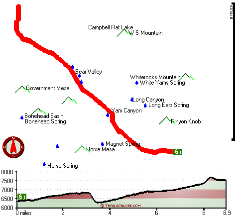
Total in and out hiking length = 17.8 miles
Total climbing distance = 7.6 miles
Difficulty : Difficult
Casual Hiking Pace:
2.5 days
Fast Hiking Pace:
1.5 days
Total elevation difference: 1688 feet

Best Western Sunrise Inn, Eagar
|
39 miles away
Located in Arizona's scenic White Mountains, this Eagar, Arizona hotel prides itself on superior customer service and is close to Sunrise Ski Resort. Situated on Main Street in Eagar, the Best Weste...
|
| |
|
User input for Little Blue Creek Forty-one Trail, San Francisco Mountains, Greenlee County, Arizona:

Outdoors Recreation Near Safford, Arizona Very comprehensive list of a variety of outdoors recreation in the vicinity of Safford, Arizona, the metro area neareast to Little Blue Creek Forty-one Trail. Find info on campgrounds, hiking trails, ski resorts, lakes, beaches, parks, whitewater and more.
More Hotels and Campgrounds Near Little Blue Creek Forty-one Trail, San Francisco Mountains, Greenlee County, Arizona
| |
| |
 |
|
| These outdoors activities are available near Little Blue Creek Forty-one Trail. |
| | Trails Near Little Blue Creek Forty-one Trail:
 |
Sycamore Trail, Greenlee
County
, 4 miles away, 10 hiking miles, 2256 feet elevation difference |
 |
Blue River One Hundred One Trail, Greenlee
County
, 8 miles away, 21.7 hiking miles, 3112 feet elevation difference |
 |
Horse Canyon Trail Thirty-six, Greenlee
County
, 9 miles away, 9.3 hiking miles, 3378 feet elevation difference |
 |
Foote Creek Seventy-six Trail, Greenlee
County
, 11 miles away, 9.5 hiking miles, 2865 feet elevation difference |
 |
Stray Horse Canyon Trail Twenty, Greenlee
County
, 11 miles away, 13.6 hiking miles, 894 feet elevation difference |
 |
Raspberry Trail Thirty-five, Greenlee
County
, 12 miles away, 8.1 hiking miles, 3036 feet elevation difference |
 |
Steeple Mesa Seventy-Three Trail, Greenlee
County
, 13 miles away, 14.6 hiking miles, 2887 feet elevation difference |
|
| | Whitewater Near Little Blue Creek Forty-one Trail:
 |
Blue River, Greenlee County
County
, 8 miles away, Class IV-V - 34 miles long (Blue Crossing to Forest Service Road 475) |
 |
San Francisco River, Greenlee County
County
, 18 miles away, Class -blank- - 40 miles long (Alma to Clifton) |
 |
San Francisco River, Catron County
County
, 18 miles away, Class II-III - 40 miles long (San Francisco to Pleasanton) |
 |
San Francisco River, Catron County
County
, 19 miles away, Class II - 40 miles long (Lower San Francisco Hot Springs to Clifton Arizona) |
 |
Black River - East Fork, Apache County
County
, 26 miles away, Class -blank- - 18 miles long (Diamond Rock to Wildcat Point) |
|
|
|
 |
|