| |
|
| | Alright, enough of spending all this time inside a building, time to get out, and KP Trail Seventy in Greenlee County, Arizona is a really wonderful place to spend some time. There are hiking trails all over Arizona; KP Trail Seventy in Greenlee County is one of them. Pretty far from Safford you encounter KP Trail Seventy, but hiking is such an enjoyable thing to do, and this is a tremendous place to do that. And keep in mind that there could be temporary safety restrictions in site. This backcountry walk should take you about 2.5 days, so better have |
|
big backpack to fit all the stuff you need. KP Trail Seventy gets very little precipitation; August is the wettest month with most rain, and May is the month with the least moisture. KP Trail Seventy has a total elevation difference of 2,663 feet, and that is higher than average.
| | Arizona is a fine outdoors state. There are plenty of hiking trails in Arizona; each one of them has its own character. With its 15.2 miles of walking distance; it's considered a longer trek. This backpacking trail has only one trailhead, so you're looking at an in and out hike. If you happen to be in Arizona, why not go hiking, it never gets boring. This backcountry trail sometimes gets very dry, so do check for current fire restrictions before you go if you plan to bring a stove or make a camp fire. This is just one of a large number of backpacking and | |
|
hiking trails in this region. This is a long backcountry trail, so don't forget to pack enough supplies. Backcountry backpacking here in the San Francisco Mountains is the best way to enjoy these mountaintops. Different parts of this great outdoors hiking trail are at very different
elevations, and that means that some parts of the great outdoors hiking trail could be very different from other parts of it. The length of this hiking and backpacking trail is on the longer side with an average amount of climbing distance which makes this backpacking and hiking
trail great for hard core backpackers looking for adventure. At KP Trail Seventy throughout the summertime months highs are in the 70's. When the night sets in temperatures descend down into the 40's. High temperatures throughout the wintertime are normally in the 40's with winter
lows in the 10's overnight here at KP Trail Seventy.
Briefly about the general area: Willow Spring is always fun to check out, and camping at KP Trail Seventy is good fun, Hannagan Campground is a good local campground. This location, the San Francisco Mountains, has
so much outdoors enjoyable things. Get soaked paddling on Blue River. Clell Spring is a wonderful place to stop at while you're at KP Trail Seventy, and some nearby water includes Corduroy Creek. If you love the outdoors you'll love it here in the San Francisco Mountains. Paddling
on Black River - East Fork is so much fun, and if you came for an overnight stay Stray Horse Campground is a good place to camp. So much exciting stuff to do at KP Trail Seventy, so little time. Rattlesnake Basin is a scenic place any time of year, and Burnt Corral Draw is a tremendous
location to stop by. A pleasant visit to Butterfly Cienega is a wonderful way to spend an afternoon, and why not take a little journey to Hagen Creek while you're here.
|
|
Location of Trailhead: Latitude 33.6011, Longitude -109.342 - - Directions and Road Map
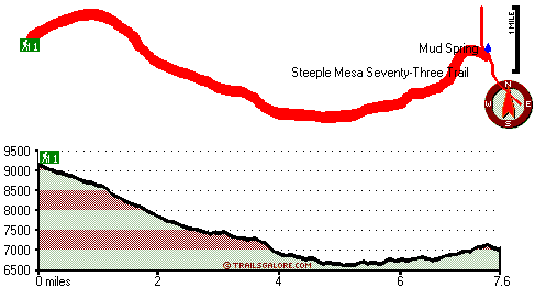
Total in and out hiking length = 15.2 miles
Total climbing distance = 7 miles
Difficulty : Difficult
Casual Hiking Pace:
2.5 days
Fast Hiking Pace:
9 hours
Total elevation difference: 2663 feet

Best Western Sunrise Inn, Eagar
|
30 miles away
Located in Arizona's scenic White Mountains, this Eagar, Arizona hotel prides itself on superior customer service and is close to Sunrise Ski Resort. Situated on Main Street in Eagar, the Best Weste...
|
| |
PVC at Roundhouse Resort, Pinetop
|
49 miles away
A mountain retreat featuring log-sided cabins surrounded by towering Ponderosa Pine trees. This invigorating, yet relaxing, natural setting features year-round recreation and seasonal activities near...
|
|
User input for KP Trail Seventy, San Francisco Mountains, Greenlee County, Arizona:

Outdoors Recreation Near Safford, Arizona Very comprehensive list of a variety of outdoors recreation in the vicinity of Safford, Arizona, the metro area neareast to KP Trail Seventy. Find info on campgrounds, hiking trails, ski resorts, lakes, beaches, parks, whitewater and more.
More Hotels and Campgrounds Near KP Trail Seventy, San Francisco Mountains, Greenlee County, Arizona
| |
| |
 |
|
| These outdoors activities are available near KP Trail Seventy. |
| | Trails Near KP Trail Seventy:
 |
Salt House Eighteen Trail, Greenlee
County
, 4 miles away, 6.4 hiking miles, 903 feet elevation difference |
 |
Steeple Mesa Seventy-Three Trail, Greenlee
County
, 5 miles away, 14.6 hiking miles, 2887 feet elevation difference |
 |
Crabtree Trail Twenty-two, Greenlee
County
, 5 miles away, 11.2 hiking miles, 1810 feet elevation difference |
 |
Raspberry Trail Thirty-five, Greenlee
County
, 5 miles away, 8.1 hiking miles, 3036 feet elevation difference |
 |
Lengthy Canyon Trail Eighty-nine, Greenlee
County
, 5 miles away, 4.4 hiking miles, 1277 feet elevation difference |
 |
Chitty Canyon Trail Thirty Four, Greenlee
County
, 7 miles away, 19.2 hiking miles, 1603 feet elevation difference |
 |
Stray Horse Canyon Trail Twenty, Greenlee
County
, 7 miles away, 13.6 hiking miles, 894 feet elevation difference |
|
| | Whitewater Near KP Trail Seventy:
 |
Black River - East Fork, Apache County
County
, 11 miles away, Class -blank- - 18 miles long (Diamond Rock to Wildcat Point) |
 |
Blue River, Greenlee County
County
, 11 miles away, Class IV-V - 34 miles long (Blue Crossing to Forest Service Road 475) |
 |
San Francisco River, Greenlee County
County
, 27 miles away, Class -blank- - 40 miles long (Alma to Clifton) |
 |
San Francisco River, Catron County
County
, 30 miles away, Class II - 40 miles long (Lower San Francisco Hot Springs to Clifton Arizona) |
|
|
|
 |
|