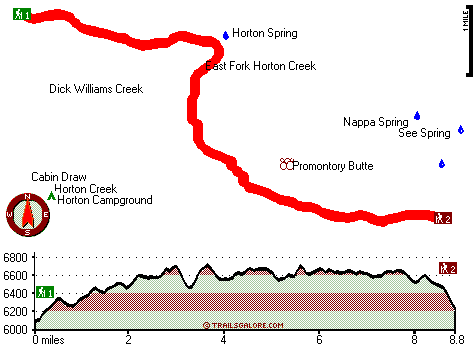
| |
|
| | Ok, you've been cooped up too long, time to get out in the great outdoors a bit, and Horton Creek Trail in Gila County, Arizona is a perfect location for getting out. Pretty far from Payson you bump into Horton Creek Trail, but you always have a perfect time when you're backcountry backpacking along it. There are many tremendous backcountry trails in Arizona, and Horton Creek Trail is one of them, and it's in Gila County. Here in Arizona hiking is a good idea. Every single Arizona backcountry trail has its own unique loveliness. A visit to Arizona is not |
|
complete without some trekking. Keep in mind that this is a long hiking trail, so make sure you bring plenty of supplies. Now, this is roughly a 2.5-day backcountry walk, so it's a fine thing if your backpack is big enough to do the job. This backpacking trail has two trailheads,
| | so if you can get a ride from someone, you can backcountry walk it just one way. Horton Creek Trail is a very long wilderness hiking trail having an average number of uphill miles which makes this a very tough hiking trail for advanced backcountry hikers looking for an outstanding challenge. The total elevation difference for this backpacking trail is 722 feet which is a lower than average number. High temperatures at Horton Creek Trail through the summertime are in the 90's, and the nighttime is quite colder of course, usually in the 50's. Daytime highs | |
|
through the wintertime are in the 50's, and after the sun is down through the wintertime temperatures at Horton Creek Trail fall into the 20's. This hiking trail sometimes gets very dry, so don’t forget to check for any current fire restrictions before you go. This is an area covered
with lots of hiking trails. You spend the whole backcountry hike in roughly the same elevation zone which means the conditions are about the same from start to finish. Being 17.6 miles long; it's a long great outdoors hiking trail. Horton Creek Trail gets a typical amount of precipitation;
the wettest month of the year is generally August, that's the one that rains the most, and the driest of the months is June. And keep in mind that there could be temporary safety restrictions in place. Backcountry hiking trails like this one here in the Mogollon Rim Mountains are
a very good way to see these peaks.
Briefly about the general area: Yeah, come up here to the Mogollon Rim Mountains for a wonderful time. Tonto Creek is a great whitewater spot near Horton Creek Trail, and Horton Creek is one of the streams nearby that might be worth
checking out. Camping at Horton Campground is always a magnificent experience, and there's some flowing water close by, Dick Williams Creek is a stream you can have a look at while you're here. A tour to Horton Spring will fill your spirit with tremendous feelings, and you
ought to without doubt dedicate some time to Beaver Park if you're here at Horton Creek Trail. Be careful coming to the Mogollon Rim Mountains, you might not ever wanna return back home again. Put some time aside to spend at Tonto Spring since you're here at Horton Creek Trail,
and while you're here at Horton Creek Trail it's a splendid idea to pop by Bear Flat. Yeah, come here to Horton Creek Trail for a splendid time. If you're here, you might as well go to Big Canyon, and a perfect site to camp here at Horton Creek Trail is Knoll Lake Campground.
|
|
Location of Trailhead 1: Latitude 34.3761, Longitude -111.1003 - - Directions and Road Map
Location of Trailhead 2: Latitude 34.3346, Longitude -111.0147 - - Directions and Road Map

Trailhead 1 to Trailhead 2: Total hiking length = 8.8 miles Total climbing distance = 4.4 miles Difficulty : Difficult Casual Hiking Pace:
8 hours
Fast Hiking Pace:
4.5 hours
Trailhead 2 to Trailhead 1: Total hiking length = 8.8 miles Total climbing distance = 4.2 miles Difficulty : Difficult Casual Hiking Pace:
8 hours
Fast Hiking Pace:
4.5 hours
| | Trailhead 1 back to Trailhead 1: Total hiking length = 17.6 miles Total climbing distance = 8.6 miles Difficulty : Difficult Casual Hiking Pace:
2.5 days
Fast Hiking Pace:
2 days
Trailhead 2 back to Trailhead 2: Total hiking length = 17.6 miles Total climbing distance = 8.6 miles Difficulty : Difficult Casual Hiking Pace:
2.5 days
Fast Hiking Pace:
2 days
|
Total elevation difference: 722 feet

Kohls Ranch Lodge, Payson
|
15 miles away
Located on the Banks of Tonto Creek in the largest Ponderosa Pine Forest in the world, Kohl*s Ranch Lodge is historically famous for its western hospitality. The Lodge is near the Mogollon Rim in the ...
|
| |
Super 8 Motel Payson, Payson
|
17 miles away
The Super 8 is centrally located in Payson to enjoy local attractions like Christopher Creek. Free High Speed Internet Access Free Local Calls Outdoor Whirlpool/Hot Tub Outdoor Pool and Heated Spa Ext...
|
|
User input for Horton Creek Trail, Mogollon Rim Mountains, Gila County, Arizona:

Outdoors Recreation Near Payson, Arizona Very comprehensive list of a variety of outdoors recreation in the vicinity of Payson, Arizona, the metro area neareast to Horton Creek Trail. Find info on campgrounds, hiking trails, ski resorts, lakes, beaches, parks, whitewater and more.
|
Current weather conditions at Horton Creek Trail, Mogollon Rim Mountains, Gila County, Arizona

Local climate location: PAYSON 14 miles away

           
| |
Best Western Payson Inn, Payson
|
18 miles away
Spa closed for the season. Sorry for the inconvenience. This full-service Payson, Arizona hotel offers a variety of amenities, a deluxe continental breakfast and is close to local shopping, museums,...
|
Holiday Inn Express PAYSON, Payson
|
18 miles away
Payson is nestled among the Ponderosa pines and clean air of the Mogollon Rim. The Tonto Natural Bridge, camping, hiking, fishing, hunting and boating areas are a short drive away. The Holiday Inn Exp...
|
|
More Hotels and Campgrounds Near Horton Creek Trail, Mogollon Rim Mountains, Gila County, Arizona
| |
| |
 |
|
| These outdoors activities are available near Horton Creek Trail. |
| | Trails Near Horton Creek Trail:
 |
Highline Trail, Gila
County
, 5 miles away, 6.9 hiking miles, 2002 feet elevation difference |
 |
Bear Flat Pleasant Valley Trail, Gila
County
, 6 miles away, 7.7 hiking miles, 1293 feet elevation difference |
 |
Hells Gate Trail, Gila
County
, 6 miles away, 9.5 hiking miles, 2084 feet elevation difference |
 |
Myrtle Trail, Gila
County
, 7 miles away, 2.7 hiking miles, 1565 feet elevation difference |
|
| | Whitewater Near Horton Creek Trail:
 |
Tonto Creek, Gila County
County
, 26 miles away, Class IV(V) - 2 miles long (Box) |
 |
Chevelon Creek, Coconino/ Navajo County
County
, 29 miles away, Class -blank- - 75 miles long (Woods Canyon Lake to Little Colorado River) |
 |
East Verde River, Gila County
County
, 30 miles away, Class V+ - 34 miles long (US Route 87 to Verde River confluence) |
|
| | National Parks Near Horton Creek Trail:
 |
Tonto National Monument, Roosevelt - AZ
, 42 miles away |
 |
Montezuma Castle National Monument, Camp Verde - AZ
, 54 miles away |
 |
Tuzigoot National Monument, Clarkdale - AZ
, 54 miles away |
|
| | Hotels Near Horton Creek Trail:
 |
Kohls Ranch Lodge, Payson
, 15 miles away |
 |
Super 8 Motel Payson, Payson
, 17 miles away |
 |
Best Western Payson Inn, Payson
, 18 miles away |
 |
Holiday Inn Express PAYSON, Payson
, 18 miles away |
 |
Days Inn and Suites Payson, Payson
, 18 miles away |
|
|
|
 |
|