Arizona hiking trails - Foote Creek Seventy-six Trail, Mogollon Rim Mountains, Greenlee County

   
  Wilderness hiking trails are great and plentiful in Arizona; one of those is Foote Creek Seventy-six Trail in Greenlee County. You can't spend all your time indoors you need to get out once in a while, and Foote Creek Seventy-six Trail in Greenlee County, Arizona is just the location. Foote Creek Seventy-six Trail is quite isolated from the least distant settlement, and if you're looking for an excellent location to go backcountry trekking, this is an excellent selection. It is very waterless here at Foote Creek Seventy-six Trail regularly; most of the rain
    falls during August while May is regularly the driest month. Through the warm days of summer highs here at Foote Creek Seventy-six Trail reach the 70's, and through the night it cools down to the 40's. During the winter highs are in the 40's while the cold winter nights at Foote
Creek Seventy-six Trail are in the 10's. Some parts of Foote Creek Seventy-six Trail are much higher up than other parts of the backcountry hiking trail, and that means that some parts of the backcountry hiking trail could be very different from other parts of it. This hike should take you about 3 days, so better have big backpack to fit all the stuff you need. With its 19 miles of walking distance; it's longer than many backcountry hiking trails. The length of this backpacking trail is on the longer side having an average number of uphill miles which makes  
this great outdoors trail good for hard core backpackers looking for adventure. Arizona has lots of outdoors endeavors. This is a two-ended backpacking trail with two trailheads which means you have the option of backpacking it one way if you have someone to pick you up at the other end. Wilderness hiking trails like this one here in the Mogollon Rim Mountains are a glorious way to explore these peaks. Keep in mind that this is a long great outdoors trail, so do pack enough food to last the whole trip. Foote Creek Seventy-six Trail has a total elevation difference of 2,865 feet which is a higher than average number. This is one of many great outdoors trails in the surrounding vicinity. And keep in mind that there could be temporary safety restrictions in location. There are plenty of hiking trails in Arizona; each one of them is different from the others. Here in the great state of Arizona backpacking is something that is always fun to do. At parts of the year this region sees very little rain, so do check for current fire restrictions before you go if you plan to bring a stove or make a camp fire.

Briefly about the general area:
So much amusing stuff in the Mogollon Rim Mountains, just impressive. Put some time aside to spend at Cedar Spring if you're here at Foote Creek Seventy-six Trail, and paddling on Black River - East Fork is so much fun. Life's too short to enjoy all the exciting stuff in the Mogollon Rim Mountains. A trip to Cleveland Spring will fill your soul with brilliant feelings. There's so much to do here at Foote Creek Seventy-six Trail that you need to camp here for a while, Upper Blue Campground is a perfect place for that.
Whitewater paddling is great on Blue River, and Hannagan Gravel Pit is a delightful site to stretch your legs a bit. There's some flowing water nearby, Fishhook Creek is a stream you can stop at during your stay. You'll need more than a day to discover everything Foote Creek Seventy-six Trail has to offer, you can camp at Blue Crossing Campground. Alpine Ranger District is a brilliant forest region close to Foote Creek Seventy-six Trail; a pleasant journey to Jones Park is a glorious way to spend an afternoon.
So much amusing stuff in close proximity to Foote Creek Seventy-six Trail, definitely mind-boggling. You might want to pay a visit to Cedar Springs Canyon if you're here at Foote Creek Seventy-six Trail, and as expected Right Fork Foote Creek flows through this area.

Location of Trailhead 1: Latitude 33.6928, Longitude -109.2149
- - Directions and Road Map

Location of Trailhead 2: Latitude 33.5966, Longitude -109.1291
- - Directions and Road Map


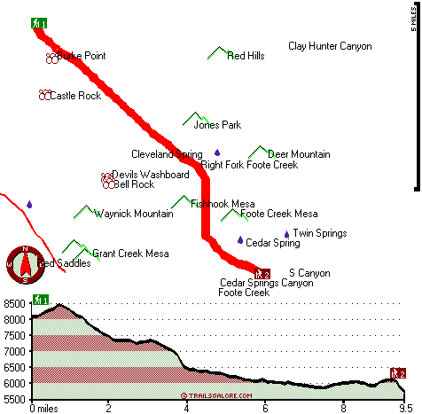
Trailhead 1 to Trailhead 2:
Total hiking length = 9.5 miles
Total climbing distance = 2.4 miles
Difficulty : Difficult
Casual Hiking Pace: 7.5 hours
Fast Hiking Pace: 4 hours

Trailhead 2 to Trailhead 1:
Total hiking length = 9.5 miles
Total climbing distance = 5.5 miles
Difficulty : Difficult
Casual Hiking Pace: 1.5 days
Fast Hiking Pace: 5.5 hours
    Trailhead 1 back to Trailhead 1:
Total hiking length = 19 miles
Total climbing distance = 7.9 miles
Difficulty : Difficult
Casual Hiking Pace: 3 days
Fast Hiking Pace: 2 days

Trailhead 2 back to Trailhead 2:
Total hiking length = 19 miles
Total climbing distance = 7.9 miles
Difficulty : Difficult
Casual Hiking Pace: 3 days
Fast Hiking Pace: 2 days

Total elevation difference: 2865 feet


Best Western Sunrise Inn, Eagar
28 miles away
Located in Arizona's scenic White Mountains, this Eagar, Arizona hotel prides itself on superior customer service and is close to Sunrise Ski Resort. Situated on Main Street in Eagar, the Best Weste...
  
User input for Foote Creek Seventy-six Trail, Mogollon Rim Mountains, Greenlee County, Arizona:

Submit Input:
Your Name:
Write or Paste Input here:

Upload picture:      Review Guidelines


Outdoors Recreation Near Safford, Arizona
Very comprehensive list of a variety of outdoors recreation in the vicinity of Safford, Arizona, the metro area neareast to Foote Creek Seventy-six Trail. Find info on campgrounds, hiking trails, ski resorts, lakes, beaches, parks, whitewater and more.

Current weather conditions at Foote Creek Seventy-six Trail, Mogollon Rim Mountains, Greenlee County, Arizona
WXPort

Local climate location: ALPINE 9 miles away


More Hotels and Campgrounds Near Foote Creek Seventy-six Trail, Mogollon Rim Mountains, Greenlee County, Arizona

OTHER_INFO
  Mogollon Rim Mountains Campgrounds
Complete list of all the campgrounds in the Mogollon Rim Mountains.

Mogollon Rim Mountains Outdoors Info
Complete outdoors info for the Mogollon Rim Mountains.

Arizona Hiking Trails
Complete list of all hiking trails in Arizona

Books about hiking trails in Arizona
List of books available on Amazon.com about hiking trails in Arizona.

Arizona Outdoors Index
This is a very comprehensive index of outdoors activities in the great state of Arizona.


TOPO
High quality water resistant topo map of Foote Creek Seventy-six Trail, Mogollon Rim Mountains, Greenlee County, Arizona.

OUTDOORS_GUIDE
These outdoors activities are available near Foote Creek Seventy-six Trail.
 Trails Near Foote Creek Seventy-six Trail:
Steeple Mesa Seventy-Three Trail, Greenlee County , 6 miles away, 14.6 hiking miles, 2887 feet elevation difference
Sycamore Trail, Greenlee County , 8 miles away,  10 hiking miles, 2256 feet elevation difference
Raspberry Trail Thirty-five, Greenlee County , 10 miles away, 8.1 hiking miles, 3036 feet elevation difference
KP Trail Seventy, Greenlee County , 10 miles away,  15.2 hiking miles, 2663 feet elevation difference
Stray Horse Canyon Trail Twenty, Greenlee County , 11 miles away,  13.6 hiking miles, 894 feet elevation difference
Little Blue Creek Forty-one Trail, Greenlee County , 11 miles away,  17.8 hiking miles, 1688 feet elevation difference
Lengthy Canyon Trail Eighty-nine, Greenlee County , 12 miles away,  4.4 hiking miles, 1277 feet elevation difference
 Camp Grounds Near Foote Creek Seventy-six Trail:
Blue Crossing Campground, Greenlee County, 5 miles away
Upper Blue Campground, Greenlee County, 7 miles away
Benny Creek Group Area - Apache-Sitgreaves National Forest, Alpine, 10 miles away
Woods Canyon Lake - Apache-Sitgreaves National Forest, Alpine, 10 miles away
Hannagan Campground, Greenlee County, 11 miles away
 Whitewater Near Foote Creek Seventy-six Trail:
Blue River, Greenlee County County , 11 miles away, Class IV-V - 34 miles long (Blue Crossing to Forest Service Road 475)
Black River - East Fork, Apache County County , 16 miles away, Class -blank- - 18 miles long (Diamond Rock to Wildcat Point)
San Francisco River, Catron County County , 26 miles away, Class II-III - 40 miles long (San Francisco to Pleasanton)
San Francisco River, Greenlee County County , 27 miles away, Class -blank- - 40 miles long (Alma to Clifton)
San Francisco River, Catron County County , 29 miles away, Class II - 40 miles long (Lower San Francisco Hot Springs to Clifton Arizona)
 Hotels Near Foote Creek Seventy-six Trail:
Best Western Sunrise Inn, Eagar , 28 miles away

Outdoors related information copyright © Stratus-Pikpuk, Inc. - Detailed hotel information copyright © Interactive Hotel Solutions