| |
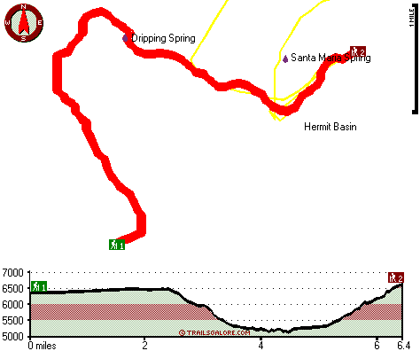
The total elevation difference for Dripping Springs Trail is 1,838 feet which is an average number. Being 12.8 miles long; it's a long hiking and backpacking trail. Dripping Springs Trail is quite long, so don't forget to pack enough supplies. This backcountry trek should take you about 2 days, so it's a great thing if your backpack is big enough to do the job. Dripping Springs Trail goes through some very different elevations, so keep in mind that you may need to dress differently at different elevations. At parts of the year this neighborhood sees very little rain, so do check for current fire restrictions before you go if you plan to bring a stove or make a camp fire. Dripping Springs Trail is a two ended backcountry hiking trail with two trailheads which means you have the option of trekking it one way if you have someone to pick you up at the other end.
|
Trailhead 1 to Trailhead 2:
Total hiking length = 6.4 miles
Total climbing distance = 3 miles
Difficulty : Difficult
Casual Hiking Pace:
6 hours
Fast Hiking Pace:
3 hours
Trailhead 2 to Trailhead 1:
Total hiking length = 6.4 miles
Total climbing distance = 2 miles
Difficulty : Difficult
Casual Hiking Pace:
5 hours
Fast Hiking Pace:
3 hours
| | Trailhead 1 back to Trailhead 1:
Total hiking length = 12.8 miles
Total climbing distance = 5 miles
Difficulty : Difficult
Casual Hiking Pace:
2 days
Fast Hiking Pace:
7 hours
Trailhead 2 back to Trailhead 2:
Total hiking length = 12.8 miles
Total climbing distance = 5 miles
Difficulty : Difficult
Casual Hiking Pace:
2 days
Fast Hiking Pace:
7 hours
|
Total elevation difference: 1838 feet
|


