| |
|
| | Here in Arizona backcountry trekking is something that is always fun to do. Alright, enough of spending all this time inside a building, time to get out, and Club Ranch Trail in Yavapai County, Arizona is a really tremendous site to spend some time. Backpacking trails for backcountry trekking, and backpacking can be found all over Arizona; one of them being Club Ranch Trail in Yavapai County. Club Ranch Trail is 25 miles long; it's longer than many hiking trails. Different parts of Club Ranch Trail are at very different elevations, so keep in mind that you |
|
may need to dress differently at different elevations. This backcountry trail has only one trailhead, so in and out is the way to walk it normally. Club Ranch Trail has a total elevation difference of 3,154 feet which is a higher than average number. This walk should take you about
| | 4 days, so it's a splendid thing if your backpack is big enough to do the job. Club Ranch Trail is quite long, so make sure you bring plenty of supplies. Arizona has so much to offer the outdoors lovers. Backcountry backpacking here in the Mogollon Rim Mountains is a very nice way to see these mountains. And keep in mind that there could be temporary safety restrictions in location. Club Ranch Trail is situated a relatively lengthy tour from Phoenix-Mesa-Scottsdale, but what a fine site for backcountry hiking it is. This wilderness trail is many miles | |
|
long having an average number of uphill miles which makes this backcountry hiking trail splendid for hard core backpackers looking for adventure. Not much rainfall falls here at Club Ranch Trail; all through the month of August you get the most rain around here, and June is the
month with the least moisture. This is a region covered with lots of backcountry hiking trails. High temperatures at Club Ranch Trail throughout the warm days of summer are in the 100's, and during summer nights temperatures are in the 60's. Highs during the winter are typically
in the 50's, and night lows at Club Ranch Trail during the winter typically sink into the 30's. Sometimes this great outdoors trail gets really dry, so do check for current fire restrictions before you go if you plan to bring a stove or make a camp fire. Every backcountry hiking
trail in Arizona is well worth a backcountry walk.
Briefly about the general area: You must undeniably dedicate some time to Squaw Flat while you're here at Club Ranch Trail; Sandy Saddle is undeniably a brilliant spot to pop by. Jakes Corner RV Park is a tremendous
local campground. There's a forest here at Club Ranch Trail called Cypress Thicket, and get yourself into a kayak and hit Verde River. Just can't get enough of Club Ranch Trail. Drift down the rapids of Verde River in a kayak, and hey, Bear Creek is a nice local stream. Be
careful coming to the Mogollon Rim Mountains, you might not ever wanna go back home again. If you're here at Club Ranch Trail, do take a visit to Cat Bay, and Rock Spring is a beautiful place to have a look at while you're at Club Ranch Trail. That right there is a load of
entertaining stuff already but it goes on, the Mogollon Rim Mountains has it all. Do set aside some time for Maverick Basin if you're here at Club Ranch Trail, and if you came for an overnight stay Oxbow Estates RV Park is a delightful site to camp. Red Rock Spring is a great local attraction; some of the water close by flows, like Mazatzal Wash.
|
|
Location of Trailhead: Latitude 34.007, Longitude -111.6396 - - Directions and Road Map
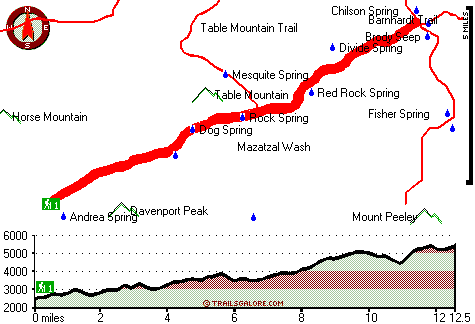
Total in and out hiking length = 25 miles
Total climbing distance = 11.4 miles
Difficulty : Difficult
Casual Hiking Pace:
4 days
Fast Hiking Pace:
2.5 days
Total elevation difference: 3154 feet

Paysonglo Lodge, Payson
|
18 miles away
Nestled among the majestic mountains of the Mogollon Rim lies a unique and serene Payson Arizona hotel: Paysonglo Lodge. The perfect spot for a Payson AZ hotel getaway. Here in Payson we offer more...
|
| |
Americas Best Value Inn - Payson, Payson
|
18 miles away
Welcome to the Americas Best Value Inn. Our hotel is strategically located in Payson, the largest community in Arizona Rim Country. Payson is also one of the fastest growing vacation centers in the ar...
|
|
User input for Club Ranch Trail, Mogollon Rim Mountains, Yavapai County, Arizona:

Outdoors Recreation Near Phoenix-Mesa-Scottsdale, Arizona Very comprehensive list of a variety of outdoors recreation in the vicinity of Phoenix-Mesa-Scottsdale, Arizona, the metro area neareast to Club Ranch Trail. Find info on campgrounds, hiking trails, ski resorts, lakes, beaches, parks, whitewater and more.
|
Current weather conditions at Club Ranch Trail, Mogollon Rim Mountains, Yavapai County, Arizona

Local climate location: CHILDS 12 miles away

           
| |
Days Inn and Suites Payson, Payson
|
18 miles away
Welcome to the Days Inn & Suites of Payson. When you are visiting Payson next, take refuge in this comfortable interior hotel. Experience the difference and we are sure you will make it your home aw...
|
Holiday Inn Express PAYSON, Payson
|
19 miles away
Payson is nestled among the Ponderosa pines and clean air of the Mogollon Rim. The Tonto Natural Bridge, camping, hiking, fishing, hunting and boating areas are a short drive away. The Holiday Inn Exp...
|
|
More Hotels and Campgrounds Near Club Ranch Trail, Mogollon Rim Mountains, Yavapai County, Arizona
| |
| |
 |
|
| These outdoors activities are available near Club Ranch Trail. |
| | Trails Near Club Ranch Trail:
 |
Table Mountain Trail, Yavapai
County
, 4 miles away, 27.2 hiking miles, 3116 feet elevation difference |
 |
Willow Spring Trail, Yavapai
County
, 4 miles away, 34.2 hiking miles, 5105 feet elevation difference |
 |
Mazatzal Divide, Yavapai
County
, 4 miles away, 26.3 hiking miles, 4287 feet elevation difference |
 |
Barnhardt Trail, Gila
County
, 5 miles away, 11.6 hiking miles, 2143 feet elevation difference |
 |
Shake Tree Trail, Gila
County
, 7 miles away, 10.2 hiking miles, 2355 feet elevation difference |
 |
North Peak Trail, Gila
County
, 8 miles away, 8.2 hiking miles, 2380 feet elevation difference |
 |
Verde River Trail Number Eleven, Yavapai
County
, 12 miles away, 14.6 hiking miles, 462 feet elevation difference |
|
| | Whitewater Near Club Ranch Trail:
 |
Verde River, Yavapai / Maricopa County
County
, 11 miles away, Class I-II - 19 miles long (Horseshoe Reservoir to Bartlett Reservoir) |
 |
Verde River, Yavapai County
County
, 14 miles away, Class I-III - 25 miles long (Childs to Horseshoe Reservoir) |
 |
East Verde River, Gila County
County
, 14 miles away, Class V+ - 34 miles long (US Route 87 to Verde River confluence) |
 |
Tonto Creek, Gila County
County
, 16 miles away, Class IV(V) - 2 miles long (Box) |
 |
Verde River, Maricopa County
County
, 22 miles away, Class I-II - 19 miles long (Bartlett Reservoir to confluence with Salt River) |
|
| | National Parks Near Club Ranch Trail:
 |
Montezuma Castle National Monument, Camp Verde - AZ
, 36 miles away |
 |
Tonto National Monument, Roosevelt - AZ
, 44 miles away |
 |
Casa Grande Ruins National Monument, Coolidge - AZ
, 62 miles away |
|
| | Hotels Near Club Ranch Trail:
 |
Paysonglo Lodge, Payson
, 18 miles away |
 |
Americas Best Value Inn - Payson, Payson
, 18 miles away |
 |
Days Inn and Suites Payson, Payson
, 18 miles away |
 |
Holiday Inn Express PAYSON, Payson
, 19 miles away |
 |
Best Western Payson Inn, Payson
, 19 miles away |
|
|
|
 |
|