Arizona hiking trails - Carter Canyon Number Thirty four Trail, Graham County

   
  Carter Canyon Number Thirty four Trail is a long trip away from Safford, but when you spend some time hiking here you will feel like a whole new person. There are backpacking trails all over Arizona, and Carter Canyon Number Thirty four Trail in Graham County is one of them. Arizona is a wonderful spot for walkers. Carter Canyon Number Thirty four Trail is a normal length wilderness hiking trail having an average number of uphill miles which makes this a very tough great outdoors hiking trail for advanced backcountry trekkers looking for a wonderful challenge.
    At parts of the year this vicinity sees very little rain, so do check for current fire restrictions before you go if you plan to bring a stove or make a camp fire. Carter Canyon Number Thirty four Trail is a one trailhead hiking trail, so you'll be hiking it in and back out. This
is a region covered with lots of great outdoors hiking trails. Different parts of this wilderness trail are at very different elevations, so keep in mind that you may need to dress differently at different elevations. And keep in mind that there could be temporary safety restrictions in place. Backcountry hiking here in Arizona is a splendid idea. The time needed for this trek is roughly 7.5 hours, but of course some folks walk a bit slower and some a bit faster. Hey, time for a hike don’t you think? Carter Canyon Number Thirty four Trail in Graham County,  
Arizona is just the site. All through the warm days of summer highs here at Carter Canyon Number Thirty four Trail get into the 90's while nighttime lows are usually in the 70's. All through the wintertime the highs are usually in the 50's, and after the sun is down during the wintertime temperatures at Carter Canyon Number Thirty four Trail sink into the 30's. Carter Canyon Number Thirty four Trail has a total elevation difference of 2,392 feet, and that is about average. This is a hiking trail that is quite long, so do pack enough food to last the whole trip. Not much rainfall falls here at Carter Canyon Number Thirty four Trail; the month with most of the rain is August, and the driest month is June. Being 8.4 miles long it's a mid length trek. Each one of the many backpacking trails of Arizona has its own unique attractiveness.

Briefly about the general area:
If you're here at Carter Canyon Number Thirty four Trail, you could stop by Hells Hole Creek, and camping is available at Riggs Flat Campground. You ought to undeniably dedicate some time to Bear Basin since you're here at Carter Canyon Number Thirty four Trail; Carter Sawmill Spring is a lovely place to have a look at while you're at Carter Canyon Number Thirty four Trail.
If you came for an overnight stay Soldier Creek Campground is a fine place to camp; if you wish for a little side tour, try Carter Canyon. This is no place for people who don’t like to have fun. If you haven’t been to Chiricahua National Monument, you should schedule some time for it while you're here. Do set aside some time for C P Flat if you're here at Carter Canyon Number Thirty four Trail, and a short trip to Manzanita Spring is always worthwhile.

Location of Trailhead: Latitude 32.7911, Longitude -109.9911
- - Directions and Road Map

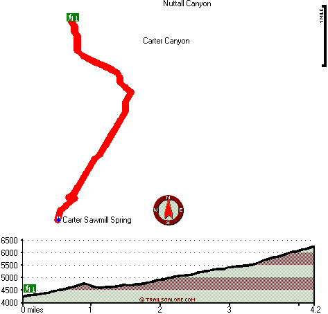
Total in and out hiking length = 8.4 miles

Total climbing distance = 3.7 miles

Difficulty : Difficult

Casual Hiking Pace: 7.5 hours

Fast Hiking Pace: 5 hours

Total elevation difference: 2392 feet


SpringHill Suites Thatcher, Thatcher
17 miles away
Fresh, stylish, new, and plugged in, the SpringHill Suites by Marriott? Thatcher-Safford hotel is perfect for your stay. At this hotel in Thatcher-Safford, AZ, you'll discover an energizing blend of ...
  
Comfort Inn & Suites Thatcher, Thatcher
17 miles away
Beautiful hotel nestled in the heart of the Gila Valley and built with the corporate traveler in mind. Get your work done in our business center or in the privacy of your room using your free WIFI and...
User input for Carter Canyon Number Thirty four Trail, Graham County, Arizona:

Submit Input:
Your Name:
Write or Paste Input here:

Upload picture:      Review Guidelines


Outdoors Recreation Near Safford, Arizona
Very comprehensive list of a variety of outdoors recreation in the vicinity of Safford, Arizona, the metro area neareast to Carter Canyon Number Thirty four Trail. Find info on campgrounds, hiking trails, ski resorts, lakes, beaches, parks, whitewater and more.

Current weather conditions at Carter Canyon Number Thirty four Trail, Graham County, Arizona
WXPort

Local climate location: SAN CARLOS RESERVOIR 29 miles away

Super 8 Safford, Safford
18 miles away
Welcome to the Super 8 Safford, minutes from Roper Lake State Park. The Super 8 is located in the heart of Gila Valley in the Pinaleno or Graham Mountain Range. This Safford Super 8 is close to Rope...

Best Western Desert Inn, Safford
18 miles away
This Safford hotel features newly renovated guest rooms and great lodging in Graham County, Arizona. The Best Western Desert Inn offers beautiful mountain views as well as great amenities and custo...

More Hotels and Campgrounds Near Carter Canyon Number Thirty four Trail, Graham County, Arizona

OTHER_INFO
  Arizona Hiking Trails
Complete list of all hiking trails in Arizona

Books about hiking trails in Arizona
List of books available on Amazon.com about hiking trails in Arizona.

Arizona Outdoors Index
This is a very comprehensive index of outdoors activities in the great state of Arizona.


TOPO
High quality water resistant topo map of Carter Canyon Number Thirty four Trail, Graham County, Arizona.

OUTDOORS_GUIDE
These outdoors activities are available near Carter Canyon Number Thirty four Trail.
 Trails Near Carter Canyon Number Thirty four Trail:
Clark Park Trail Three hundred one, Graham County , 3 miles away,  2.8 hiking miles, 524 feet elevation difference
Shingle Mill Mesa Thirty Five Trail, Graham County , 5 miles away,  19.2 hiking miles, 3225 feet elevation difference
Jesus Goudy Ridge Trail Two hundred ninety eight, Graham County , 6 miles away, 7 hiking miles, 4669 feet elevation difference
Grant Creek Three hundred five Trail, Graham County , 6 miles away,  10 hiking miles, 4569 feet elevation difference
Ash Creek Trail Three Hundred Seven, Graham County , 8 miles away, 7.4 hiking miles, 5955 feet elevation difference
Round the Mountain Trail, Graham County , 12 miles away, 6 hiking miles, 2610 feet elevation difference
Noon Creek Trail, Graham County , 13 miles away, 4.3 hiking miles, 2117 feet elevation difference
 Camp Grounds Near Carter Canyon Number Thirty four Trail:
Riggs Flat Campground, Graham County, 4 miles away
Soldier Creek Campground, Graham County, 6 miles away
Hospital Flat Campground, Graham County, 9 miles away
Shannon Campground, Graham County, 11 miles away
Arcadia Campground, Graham County, 13 miles away
 National Parks Near Carter Canyon Number Thirty four Trail:
Chiricahua National Monument, Willcox - AZ , 24 miles away
Fort Bowie National Historic Site, Willcox - AZ , 57 miles away
Saguaro National Park, Tucson - AZ , 66 miles away
 Hotels Near Carter Canyon Number Thirty four Trail:
SpringHill Suites Thatcher, Thatcher , 17 miles away
Comfort Inn & Suites Thatcher, Thatcher , 17 miles away
Super 8 Safford, Safford , 18 miles away
Best Western Desert Inn, Safford , 18 miles away
Quality Inn & Suites, Safford , 20 miles away

Outdoors related information copyright © Stratus-Pikpuk, Inc. - Detailed hotel information copyright © Interactive Hotel Solutions