Arizona hiking trails - Black Mesa Trail, Maricopa County

   
  Going for a walk here in Arizona is always an enjoyable thing to do. Fine hiking trails in Arizona are in abundance, and Black Mesa Trail in Maricopa County is one of them. There are numerous hiking trails in Arizona, and each one is well worth a walk. During the months of summer, highs typically are in the 100's at Black Mesa Trail; the overnight is somewhat colder of course, frequently in the 70's. The cold days of the winter come with highs in the 60's with winter lows in the 30's overnight here at Black Mesa Trail. This backcountry hike shouldn't take
    more than 7.5 hours, but you never know stuff could go wrong and you could get stuck so be prepared for that. This is just one of a large number of backcountry trails in this vicinity. Being 8.2 miles long it's a mid length backcountry walk. Black Mesa Trail is a mid-length great
outdoors trail having an average number of uphill miles which makes this a very tough backcountry trail for advanced backcountry walkers looking for a nice challenge. Black Mesa Trail has only one trailhead, so you'll be backpacking it in and back out. Black Mesa Trail is usually a rather waterless location; the wettest month of the year is usually March, that's the one that rains the most while May is the month with the least amount of precipitation. Black Mesa Trail has a total elevation difference of 657 feet which is lower than average. This great outdoors  
trail sometimes gets very dry, so make sure you check current conditions and fire restrictions with local forest authorities before you head out. Quite far from Payson you bump into Black Mesa Trail, but when you spend some time backcountry backpacking here you will feel like a whole new person. Don’t forget to check for any current restrictions or closures before you go. Arizona is a tremendous site for hikers. Hitting the backpacking trails is always an enjoyable thing to do, and Black Mesa Trail in Maricopa County, Arizona is just what you need. There's not much difference in elevation along Black Mesa Trail, so you get pretty much the same conditions along the whole hiking trail. This is a great outdoors trail that is quite long, so don't forget to pack enough supplies.

Briefly about the general area:
The beauty of mother nature reveals herself at Willow Spring, and you must positively dedicate some time to Marsh Valley since you're here at Black Mesa Trail. The surroundings of this river have so much to offer. A trip to Black Mesa Trail wouldn't be complete without taking a look at Second Water Spring; Black Mesa Trail is a magnificent place to camp, Peralta Canyon Campground is a magnificent place.
Salt River is a good whitewater spot next to Black Mesa Trail, and a perfect place like Garden Valley here at Black Mesa Trail is too good to miss. Why not stop at nearby Mesquite Creek if you're here at Black Mesa Trail; camping at Black Mesa Trail is nice fun, Carney Springs Campground is a nice local campground.
Whohoo, so many fun things in one place! Black Mesa Trail is great! Since you're here at Black Mesa Trail why not stop at Needle Canyon; don't forget to take a splendid little visit to La Barge Creek.

Location of Trailhead: Latitude 33.4788, Longitude -111.4371
- - Directions and Road Map

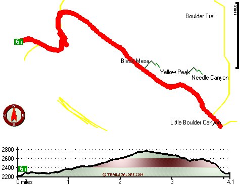
Total in and out hiking length = 8.2 miles

Total climbing distance = 3.8 miles

Difficulty : Difficult

Casual Hiking Pace: 7.5 hours

Fast Hiking Pace: 5 hours

Total elevation difference: 657 feet


Gold Canyon Golf Resort, Gold Canyon
7 miles away
The resorts 85 unique Casitas offer a variety of amenities such as Indoor or Outdoor Spas, Suites, Wood Burning Fireplaces, and Private Patios with splendid views of the majestic Superstition Mountain...
  
Best Western Gold Canyon Inn & Suites, Gold Canyon
8 miles away
Discover this Gold Canyon hotel located next to the Superstition Mountains and offering a complimentary continental breakfast. Whether traveling on business or for pleasure, the Best Western Gold Can...
User input for Black Mesa Trail, Maricopa County, Arizona:

Submit Input:
Your Name:
Write or Paste Input here:

Upload picture:      Review Guidelines


Outdoors Recreation Near Payson, Arizona
Very comprehensive list of a variety of outdoors recreation in the vicinity of Payson, Arizona, the metro area neareast to Black Mesa Trail. Find info on campgrounds, hiking trails, ski resorts, lakes, beaches, parks, whitewater and more.

Current weather conditions at Black Mesa Trail, Maricopa County, Arizona
WXPort

Local climate location: BARTLETT DAM 1 miles away

Apache Junction Super 8 Motel, Apache Junction
11 miles away
AAA Approved/2 Diamonds Complimentary SuperStart Breakfast Wireless high speed internet in all rooms MicroFridge, in-room coffee makers, hair dryers, 27 " cable TV w/HBO Located at t...

Best Western Apache Junction Inn, Apache Junction
11 miles away
This Apache Junction hotel just outside of Phoenix offers great accommodations and the beautiful scenery of the Superstition Mountains. The Best Western Apache Junction Inn is conveniently located w...

More Hotels and Campgrounds Near Black Mesa Trail, Maricopa County, Arizona

OTHER_INFO
  Arizona Hiking Trails
Complete list of all hiking trails in Arizona

Books about hiking trails in Arizona
List of books available on Amazon.com about hiking trails in Arizona.

Arizona Outdoors Index
This is a very comprehensive index of outdoors activities in the great state of Arizona.


TOPO
High quality water resistant topo map of Black Mesa Trail, Maricopa County, Arizona.

OUTDOORS_GUIDE
These outdoors activities are available near Black Mesa Trail.
 Trails Near Black Mesa Trail:
Boulder Trail, Maricopa County , 1 miles away,  13.6 hiking miles, 659 feet elevation difference
Red Hills Trail, Maricopa County , 2 miles away,  9.6 hiking miles, 502 feet elevation difference
Second Water Trail, Maricopa County , 2 miles away,  6 hiking miles, 534 feet elevation difference
West Boulder Trail, Pinal County , 2 miles away, 7.2 hiking miles, 1623 feet elevation difference
Needle Trail, Pinal County , 3 miles away,  9 hiking miles, 1203 feet elevation difference
Peralta Trail, Pinal County , 4 miles away,  11.2 hiking miles, 1340 feet elevation difference
Cave Trail, Pinal County , 5 miles away,  4.4 hiking miles, 1711 feet elevation difference
 Camp Grounds Near Black Mesa Trail:
Carney Springs Campground, Pinal County, 5 miles away
Peralta Canyon Campground, Pinal County, 6 miles away
Lost Dutchman State Park, Apache Junction, 6 miles away
Gold Canyon RV And Golf Resort, Apache Junction, 8 miles away
Canyon Lake Marina And Campground, Apache Junction, 9 miles away
 Whitewater Near Black Mesa Trail:
Salt River, Gila County County , 15 miles away, Class -blank- - 12 miles long (Stewart Mountain Dam to Granite Reef Dam)
 National Parks Near Black Mesa Trail:
Tonto National Monument, Roosevelt - AZ , 29 miles away
Casa Grande Ruins National Monument, Coolidge - AZ , 30 miles away
Hohokam Pima National Monument, Coolidge - AZ , 30 miles away
 Hotels Near Black Mesa Trail:
Kings Ranch Gold Canyon's Rnch., Apache Junction , 6 miles away
Gold Canyon Golf Resort, Gold Canyon , 7 miles away
Best Western Gold Canyon Inn & Suites, Gold Canyon , 8 miles away
Palm Springs Motel, Apache Junction , 10 miles away
Apache Junction Super 8 Motel, Apache Junction , 11 miles away

Outdoors related information copyright © Stratus-Pikpuk, Inc. - Detailed hotel information copyright © Interactive Hotel Solutions