| |
Bear Flat Pleasant Valley Trail has two trailheads, so backcountry backpacking it one way is an option if you can arrange for a ride back. Being 15.4 miles long; it's longer than many wilderness hiking trails. The total elevation difference for this great outdoors hiking trail is 1,293 feet, and that is about average. This is a backpacking trail that is quite long, so don't forget to pack enough supplies. There's not much difference in elevation along the wilderness hiking trail which means the conditions are about the same from start to finish. This backpacking trail sometimes gets very dry, so don’t forget to check for any current fire restrictions before you go. Now, this is roughly a 2.5-day backcountry hike, so make sure you've got all your overnight gear packed.
|
Trailhead 1 to Trailhead 2:
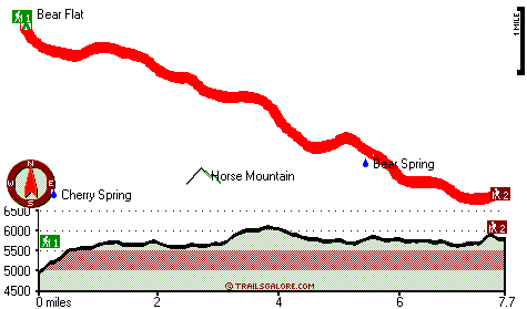
Total hiking length = 7.7 miles
Total climbing distance = 4 miles
Difficulty : Difficult
Casual Hiking Pace:
7.5 hours
Fast Hiking Pace:
4 hours
Trailhead 2 to Trailhead 1:
Total hiking length = 7.7 miles
Total climbing distance = 3.1 miles
Difficulty : Difficult
Casual Hiking Pace:
6.5 hours
Fast Hiking Pace:
3.5 hours
| | Trailhead 1 back to Trailhead 1:
Total hiking length = 15.4 miles
Total climbing distance = 7.1 miles
Difficulty : Difficult
Casual Hiking Pace:
2.5 days
Fast Hiking Pace:
9 hours
Trailhead 2 back to Trailhead 2:
Total hiking length = 15.4 miles
Total climbing distance = 7.1 miles
Difficulty : Difficult
Casual Hiking Pace:
2.5 days
Fast Hiking Pace:
9 hours
|
Total elevation difference: 1293 feet
|


