| |
|
| | Trails for hiking, and backpacking can be found all over Arizona, and one of those is Bass Trail in Coconino County. Here in Arizona hiking is a tremendous idea. No chance of getting bored in Arizona if you like the fresh air. Being 22.6 miles long; it's longer than many trails. Please follow all local rules about fires and camping. Bass Trail is a one trailhead wilderness trail, so you're looking at an in and out hike. At Bass Trail through the days of summer highs are in the 90's. All through the dark hours of summer temperatures sink down into the 50's. |
|
All through the winter highs are in the 40's with temperatures at Bass Trail dipping down into the 20's during winter nights. This is one of a very small number of wilderness hiking trails in this area. Around Bass Trail you don’t get a lot of rain; the wettest month of the year
| | is typically August, that's the one that rains the most, and June on the other hand is the driest. This trek should take you about 3.5 days, so better have big backpack to fit all the stuff you need. Every Arizona hiking trail has its own unique loveliness. The total elevation difference for this wilderness trail is 6,116 feet which is a higher than average number. At parts of the year this area sees very little rain, so do check for current fire restrictions before you go if you plan to bring a stove or make a camp fire. When was the last time you got | |
|
out in the outdoors a bit? Bass Trail in Coconino County, Arizona is just what you need. Now this hiking and backpacking trail is pretty long, so do pack enough food to last the whole trip. Some parts of this trail are much higher up than other parts of the trail, so keep in mind
that you may need to dress differently at different elevations. Bass Trail is a very long trail having an average number of uphill miles which makes this a very tough wilderness hiking trail for advanced trekkers looking for a tremendous challenge. Bass Trail is in a pretty secluded
area, and hiking trails like these are splendid.
Briefly about the general area: It's always tremendous to have a look at Shinumo Rapids; there are some nice whitewater spots on Colorado River. It's a good idea to stop by White Creek, it's near Bass Trail, and a pleasant
spree to Rainbow Plateau is a great way to spend an afternoon. A great place to pop by close to Bass Trail is Muav Canyon, and Bass Trail is a delightful place to visit for more than one day, DeMotte Campground is a delightful place to camp nearby. Why not take a look at Point
Sublime also while you're here, and Hotauta Amphitheater is a delightful location any time of year. Indian Hollow Campground is a glorious local campground, and if you're looking for a brilliant tour, Grand Canyon National Park is pretty near. Now, you may believe that's heaps
but there's even more exciting stuff to do here at Bass Trail. Don't leave Bass Trail without first paying a visit to Bass Rapids, and a quick visit to Flint Creek is certainly a brilliant idea.
|
|
Location of Trailhead: Latitude 36.3376, Longitude -112.3496 - - Directions and Road Map
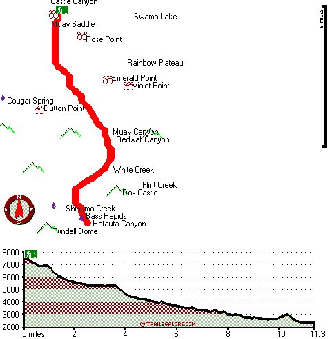
Total in and out hiking length = 22.6 miles
Total climbing distance = 9.3 miles
Difficulty : Difficult
Casual Hiking Pace:
3.5 days
Fast Hiking Pace:
2 days
Total elevation difference: 6116 feet

|
| |
The Grand Hotel, Grand Canyon
|
18 miles away
Guests of The Grand Hotel enjoy gateway access to Grand Canyon National Park and a variety of recreational activities. The lodge, built in 1998, features the classic architecture and decor of America'...
|
|
User input for Bass Trail, Coconino County, Arizona:

Outdoors Recreation Near Flagstaff, Arizona Very comprehensive list of a variety of outdoors recreation in the vicinity of Flagstaff, Arizona, the metro area neareast to Bass Trail. Find info on campgrounds, hiking trails, ski resorts, lakes, beaches, parks, whitewater and more.
More Hotels and Campgrounds Near Bass Trail, Coconino County, Arizona
| |
| |
 |
|
| These outdoors activities are available near Bass Trail. |
| | Trails Near Bass Trail:
 |
Tonto Trail, Coconino
County
, 10 miles away, 81.8 hiking miles, 4722 feet elevation difference |
 |
Indian Hollow-Thunder Springs Trail Twenty-three, Coconino
County
, 11 miles away, 20.4 hiking miles, 5805 feet elevation difference |
 |
Boucher Trail, Coconino
County
, 13 miles away, 18.4 hiking miles, 4436 feet elevation difference |
|
| | Whitewater Near Bass Trail:
 |
Colorado River, Coconino/ Mohave County
County
, 17 miles away, Class I-V - 230 miles long (Lees Ferry to Lake Mead) |
|
| | National Parks Near Bass Trail:
 |
Grand Canyon National Park, Grand Canyon - AZ
, 18 miles away |
 |
Pipe Spring National Monument, Fredonia - AZ
, 40 miles away |
 |
Zion National Park, Springdale - UT
, 68 miles away |
|
| | Hotels Near Bass Trail:
 |
Holiday Inn Express Hotel & Suites GRAND CANYON, Grand Canyon
, 18 miles away |
 |
The Grand Hotel, Grand Canyon
, 18 miles away |
 |
Red Feather Lodge, Grand Canyon
, 18 miles away |
 |
Canyon Plaza Resort, Grand Canyon
, 22 miles away |
 |
Best Western Grand Canyon Squire Inn, Grand Canyon
, 22 miles away |
|
|
|
 |
|