Arizona hiking trails - Algonquin Trail, Yavapai County

   
  Backcountry backpacking in Arizona is always an exciting thing to do. There are numerous great outdoors trails in Arizona, and each one is worth backcountry backpacking. Backcountry trekking in Arizona is such a wonderful thing to do. Algonquin Trail is not very near Prescott at all, but when you spend some time trekking here you will feel like a whole new person. This region does get very dry sometimes, so do check for current fire restrictions before you go if you plan to bring a stove or make a camp fire. With its 11 miles of walking distance; it's
    a long hiking trail. Trails are good and plentiful in Arizona; Algonquin Trail in Yavapai County is one of them. This is a two-ended great outdoors trail with two trailheads, so if you can get a ride from someone, you can hike it just one way. Algonquin Trail is pretty dried out
typically; August is the wettest month with most rain, and June on the other hand is the driest. Hitting the wilderness trails is always a fun thing to do, and Algonquin Trail in Yavapai County, Arizona is just the site. This is a hiking trail that is quite long, so do pack enough food to last the whole trip. This great outdoors trail has a total elevation difference of 2,168 feet which is an average number. Please follow all local rules about fires and camping. All through the warmest time of the year, highs regularly are in the 80's at Algonquin Trail.  
Summer night lows sink down to the 50's. Through the winter highs are in the 40's while the cold winter nights at Algonquin Trail are in the 20's. There are so many trails in this region. Different parts of Algonquin Trail are at very different elevations, so keep in mind that you may need to dress differently at different elevations. Now, this is roughly a 1.5-day hike, so better have big backpack to fit all the stuff you need. Algonquin Trail is many miles long having an average number of uphill miles which makes this a very tough trail for advanced backcountry walkers looking for a good challenge.

Briefly about the general area:
Places like Horsethief Basin are magnificent to check out It's always good to explore Jerky Dam Spring. Kentuck Spring Campground is a great campground nearby, and a spree to Kane Spring will fill your soul with good feelings.
Some nearby water includes Jim Creek; since you're here, you might as well have a look at Horsethief Canyon. Any time is a good time at Algonquin Trail if you go for the outdoors. Copper Basin is a great spot. Horsethief Creek is in the vicinity of Algonquin Trail and is always a delight to check out, and if you came for an overnight stay Hazlett Hollow Campground is a good spot to camp.

Location of Trailhead 1: Latitude 34.2179, Longitude -112.3076
- - Directions and Road Map

Location of Trailhead 2: Latitude 34.1679, Longitude -112.3062
- - Directions and Road Map


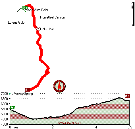
Trailhead 1 to Trailhead 2:
Total hiking length = 5.5 miles
Total climbing distance = 3 miles
Difficulty : Medium
Casual Hiking Pace: 5.5 hours
Fast Hiking Pace: 3 hours

Trailhead 2 to Trailhead 1:
Total hiking length = 5.5 miles
Total climbing distance = 1.8 miles
Difficulty : Easy
Casual Hiking Pace: 4.5 hours
Fast Hiking Pace: 2.5 hours
    Trailhead 1 back to Trailhead 1:
Total hiking length = 11 miles
Total climbing distance = 4.8 miles
Difficulty : Difficult
Casual Hiking Pace: 1.5 days
Fast Hiking Pace: 6.5 hours

Trailhead 2 back to Trailhead 2:
Total hiking length = 11 miles
Total climbing distance = 4.8 miles
Difficulty : Difficult
Casual Hiking Pace: 1.5 days
Fast Hiking Pace: 6.5 hours

Total elevation difference: 2168 feet


Hampton Inn Prescott, Prescott
21 miles away
This Arizona Hampton Inn has received the Circle of Excellence Award and Pride Award each year since opening in 2000 and the Lighthouse Award in 2003 and 2004 for guest satisfaction and service. Our g...
  
Holiday Inn Express PRESCOTT, Prescott
21 miles away
Welcome to the site of the Award Winning Holiday Inn Express Hotel - Prescott, Arizona. We are just 96 miles north of Phoenix. We are conveniently located near the entrance to Prescott's Gateway Mall...
User input for Algonquin Trail, Yavapai County, Arizona:

Submit Input:
Your Name:
Write or Paste Input here:

Upload picture:      Review Guidelines


Outdoors Recreation Near Prescott, Arizona
Very comprehensive list of a variety of outdoors recreation in the vicinity of Prescott, Arizona, the metro area neareast to Algonquin Trail. Find info on campgrounds, hiking trails, ski resorts, lakes, beaches, parks, whitewater and more.

Current weather conditions at Algonquin Trail, Yavapai County, Arizona
WXPort

Local climate location: CROWN KING 8 miles away

Hampton Inn Phoenix/Anthem, Phoenix
21 miles away
Perfectly nestled in the Arizona foothills of the high Sonoran desert and heart of Anthem is the Hampton Inn Phoenix/Anthem AZ hotel. Conveniently located directly off of I-17 and Anthem Way our Hamp...

Forest Villas Hotel, Prescott
21 miles away
Our property has become a Smoke Free facility effective immediately. A $200.00 fine will be imposed on violators. The Forest Villas Hotel has European ambience and Prescott charm. Relax in our elegan...

More Hotels and Campgrounds Near Algonquin Trail, Yavapai County, Arizona

OTHER_INFO
  Arizona Hiking Trails
Complete list of all hiking trails in Arizona

Books about hiking trails in Arizona
List of books available on Amazon.com about hiking trails in Arizona.

Arizona Outdoors Index
This is a very comprehensive index of outdoors activities in the great state of Arizona.


TOPO
High quality water resistant topo map of Algonquin Trail, Yavapai County, Arizona.

OUTDOORS_GUIDE
These outdoors activities are available near Algonquin Trail.
 Trails Near Algonquin Trail:
Twin Peaks Trail, Yavapai County , 2 miles away, 10.2 hiking miles, 2992 feet elevation difference
Tiptop Trail, Yavapai County , 3 miles away,  5 hiking miles, 1350 feet elevation difference
Lane Mountain Trail, Yavapai County , 4 miles away, 3.7 hiking miles, 3085 feet elevation difference
Bull Run Trail, Yavapai County , 4 miles away,  7.8 hiking miles, 2681 feet elevation difference
Willow Spring Trail, Yavapai County , 4 miles away,  8 hiking miles, 1533 feet elevation difference
Castle Creek Trail, Yavapai County , 4 miles away,  7.6 hiking miles, 2619 feet elevation difference
Bradshaw Trail, Yavapai County , 6 miles away, 6.2 hiking miles, 2026 feet elevation difference
 Camp Grounds Near Algonquin Trail:
Hazlett Hollow Campground, Yavapai County, 2 miles away
Kentuck Spring Campground, Yavapai County, 2 miles away
River's Edge RV Park and Camp, Black Canyon City, 12 miles away
River's Edge Recreational Vehicle Park & Camp, Black Cyn City, 12 miles away
Bradshaw Mountain Recreational Vehicle Resort, Black Cyn City, 12 miles away
 National Parks Near Algonquin Trail:
Montezuma Castle National Monument, Camp Verde - AZ , 38 miles away
Tuzigoot National Monument, Clarkdale - AZ , 38 miles away
 Hotels Near Algonquin Trail:
Hampton Inn Prescott, Prescott , 21 miles away
Holiday Inn Express PRESCOTT, Prescott , 21 miles away
Hampton Inn Phoenix/Anthem, Phoenix , 21 miles away
Forest Villas Hotel, Prescott , 21 miles away
Residence Inn Prescott, Prescott , 21 miles away

Outdoors related information copyright © Stratus-Pikpuk, Inc. - Detailed hotel information copyright © Interactive Hotel Solutions